IMAGES TAKEN NEAR TO
Veale Drive, EXETER, EX2 5GW
Introduction
This page details the photographs taken nearby to Veale Drive, EX2 5GW by members of the Geograph project.
The Geograph project started in 2005 with the aim of publishing, organising and preserving representative images for every square kilometre of Great Britain, Ireland and the Isle of Man.

There are currently over 7.5m images from over14,400 individuals and you can help contribute to the project by visiting https://www.geograph.org.uk
Image Map
Images are licensed for reuse under creativecommons.org/licenses/by-sa/2.0
Notes
- Clicking on the map will re-center to the selected point.
- The higher the marker number, the further away the image location is from the centre of the postcode.
Image Listing (214 Images Found)
Images are licensed for reuse under creativecommons.org/licenses/by-sa/2.0
Image
Details
Distance
1
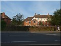
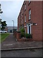
Housing in Veale Drive, Exeter
The area where this block has been built was formerly part of the nearby barracks
Image: © David Smith
Taken: 2 Aug 2019
0.01 miles
2
Veale Street, Exeter
In spite of the road name sign; Alice Templer Close turns sharp right here, and all the houses shown are in Veale Street.
Image: © Derek Harper
Taken: 29 Jan 2024
0.01 miles
3
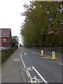
End of the cycle lane, Barrack Road, Exeter
Just at the point where there is a traffic island, forcing traffic to keep left, the cycle track stops - and then resumes as a bus and cycle lane
Image: © David Smith
Taken: 4 Oct 2015
0.02 miles
4
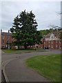
Mature tree and open space, Alice Templer Close, Exeter
Image: © David Smith
Taken: 5 May 2020
0.03 miles
5

Alice Templer Close, Exeter
Seen from the junction with Masterson Street (Image]).
Image: © Derek Harper
Taken: 29 Jan 2024
0.03 miles
6
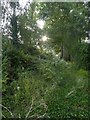
Overgrown lane off Barrack Road, Exeter
This lane formerly gave access to fields on each side; housing developments on each side have provided alternative routes for 21st century traffic.
Image: © David Smith
Taken: 2 Aug 2019
0.03 miles
7
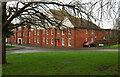
Terrace in Alice Templer Close, Exeter
The housing estate is adjacent to the barracks, and a military vehicle can be seen in the background
Image: © David Smith
Taken: 5 May 2020
0.03 miles
8
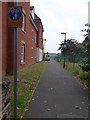
Cycle and footpath leading off Barrack Road, Exeter
A short path leading into a housing estate; on the right is the fence of the barracks
Image: © David Smith
Taken: 4 Oct 2015
0.03 miles
9
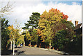
Matford Avenue, Exeter
A part of Exeter developed in the late 19th century with substantial Victorian houses on the right and mature trees. One house was destroyed by bombing in 1942.
Image: © David Smith
Taken: Unknown
0.04 miles
10
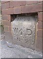
Old Boundary Marker by Barrack Road, Exeter parish
Estate Boundary Marker - War Department by the UC road, in parish of Exeter (Exeter District), Barrack Road, to left of North vehicle entrance to Wyvern Barracks, by pedestrian gate, in brick boundary pillar.
Inscription reads:-
1874
W^D
No 2
Devon & Dartmoor HER.
HER Number: MDV75142 https://www.heritagegateway.org.uk/Gateway/Results_Single.aspx?uid=MDV75142&resourceID=104
Surveyed
Milestone Society National ID: DV_EXWB02Wem
Image: © Alan Rosevear
Taken: 30 Mar 2013
0.04 miles