IMAGES TAKEN NEAR TO
Manston Terrace, EXETER, EX2 4NP
Introduction
This page details the photographs taken nearby to Manston Terrace, EX2 4NP by members of the Geograph project.
The Geograph project started in 2005 with the aim of publishing, organising and preserving representative images for every square kilometre of Great Britain, Ireland and the Isle of Man.

There are currently over 7.5m images from over14,400 individuals and you can help contribute to the project by visiting https://www.geograph.org.uk
Image Map
Images are licensed for reuse under creativecommons.org/licenses/by-sa/2.0
Notes
- Clicking on the map will re-center to the selected point.
- The higher the marker number, the further away the image location is from the centre of the postcode.
Image Listing (302 Images Found)
Images are licensed for reuse under creativecommons.org/licenses/by-sa/2.0
Image
Details
Distance
1
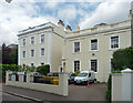
2-3 Manston Terrace, Exeter
Some grander examples of early Victorian suburbia. Grade II listed.
Image: © Stephen Richards
Taken: 18 Jun 2014
0.01 miles
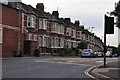
2
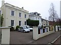
Manston Terrace, Exeter
A cul-de-sac with 19th century houses. The nearer one is used as a pre-school nursery
Image: © David Smith
Taken: 1 Nov 2015
0.01 miles
3
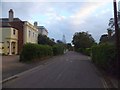
Manston Terrace, Exeter
A short road with 19th century houses on one side (some converted to flats). It leads to the main entrance of Exeter School
Image: © David Smith
Taken: 29 Aug 2012
0.02 miles
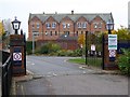
4
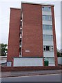
Frances Court, Barrack Road, Exeter
One of very few blocks of flats in Exeter's suburbs.
Image: © David Smith
Taken: 7 Jul 2020
0.03 miles
5
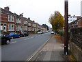
Barrack Road, Exeter
The road leads to the barracks at the junction with Topsham Road Image On one side are terraced houses, opposite are post-WW2 houses. The wall by the pole on the right is the end of a Victorian boundary wall of a property in Manston Terrace Image which formerly extended to Barrack Road
Image: © David Smith
Taken: 1 Nov 2015
0.03 miles
6
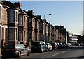
Barrack Road, Exeter
Part of a terrace of 31 houses on the east side of the road south of Image Down the road is the Peninsula Medical School building, completed in 2004 on the Wonford site of the Royal Devon & Exeter hospital.
Image: © Derek Harper
Taken: 25 Nov 2008
0.04 miles
7

A private alleyway between Barrack Road and Manston Terrace
This alleyway is used to reach the school (Exeter School) and other properties in Manston Terrace. The building on the left is used as offices.
Image: © David Smith
Taken: 3 Aug 2011
0.04 miles
9

Junction on Magdalen Road, Exeter
Magdalen Road crosses Barrack Road, which stretches ahead on the right of the photo. I'm not sure whether the stretch of road in the foreground is Barrack Road, or Polsloe Road, which continues north from a set of traffic lights just behind the camera.
Image: © Derek Harper
Taken: 25 Nov 2008
0.05 miles
10
Exeter : Barrack Road
Barrack Road from the junction at Magdalen Road in Exeter.
Image: © Lewis Clarke
Taken: 21 Sep 2012
0.06 miles