IMAGES TAKEN NEAR TO
Premier Place, EXETER, EX2 4LB
Introduction
This page details the photographs taken nearby to Premier Place, EX2 4LB by members of the Geograph project.
The Geograph project started in 2005 with the aim of publishing, organising and preserving representative images for every square kilometre of Great Britain, Ireland and the Isle of Man.

There are currently over 7.5m images from over14,400 individuals and you can help contribute to the project by visiting https://www.geograph.org.uk
Image Map
Images are licensed for reuse under creativecommons.org/licenses/by-sa/2.0
Notes
- Clicking on the map will re-center to the selected point.
- The higher the marker number, the further away the image location is from the centre of the postcode.
Image Listing (334 Images Found)
Images are licensed for reuse under creativecommons.org/licenses/by-sa/2.0
Image
Details
Distance
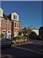
1
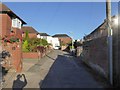
Premier Place, St Leonard's, Exeter
A residential cul-de-sac with 1930s houses and some rebuilt after Exeter's blitz.
Image: © David Smith
Taken: 10 Sep 2015
0.00 miles
2

Alas, poor snowman
This rather sad little heap is in St Petrocks Close, seen from Wonford Road.
Image: © Derek Harper
Taken: 4 Feb 2009
0.03 miles
3
Tree in garden of St Petrock's Close, Exeter
Seen from Wonford Road
Image: © David Smith
Taken: 22 Mar 2020
0.03 miles
4

Houses in Marlborough Road, Exeter
Because of old property boundaries, this residential road has a dogleg at its southern end. The picture is taken from the short connecting stretch which links a Victorian terrace (behind the camera) with the early 20th century houses ahead.
Image: © David Smith
Taken: 4 Mar 2016
0.04 miles
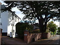
5
St Petrock's Close, off Wonford Road
A post-war development of social housing. This was the site of a row of houses, St Leonard's Terrace, which was seriously damaged by bombing during the Exeter Blitz of May 1942. The name Petrock, a Cornish saint, links to St Petrock's church in the centre of Exeter
Image: © David Smith
Taken: 15 Sep 2012
0.04 miles
6

Marlborough Road, Exeter
A curious double bend on this residential road, the north and south sections of which are offset by about 20 metres.
Image: © Derek Harper
Taken: 1 Dec 2008
0.04 miles
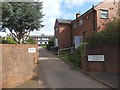
7
St Leonard's Road, Exeter
A mid-C19 villa beneath a cedar at the junction of Premier Place. The junction with Wonford Road is at the right.
Image: © Derek Harper
Taken: 25 Sep 2006
0.05 miles
8

Wonford Road, Exeter
A distinctive modern house among Victorian buildings, and one of intermediate age, on a narrow stretch of the road.
Image: © Derek Harper
Taken: 1 Dec 2008
0.05 miles
9
Architectural detail around window, Marlborough Road, Exeter
Low relief representation of plants, picked out in a muted colour
Image: © David Smith
Taken: 15 May 2020
0.05 miles
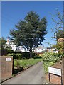
10
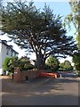
Cedar tree in St Leonard's Road, Exeter
This tree is the last remaining tree from the avenue which led to Mount Radford House, demolished in the early 20th century. The house is remembered in the name of the local pub, the Mount Radford Image, and a local road, Radford Road. On 20th August 2013, a large branch fell from the tree, and the road was closed. Tree surgeons removed further branches, so the shape differs from that in Image A county council notice about the tree was posted on the trunk in a position where it could not be read from the pavement
Image: © David Smith
Taken: 22 Aug 2013
0.05 miles