IMAGES TAKEN NEAR TO
Southgate, EXETER, EX2 4DA
Introduction
This page details the photographs taken nearby to Southgate, EX2 4DA by members of the Geograph project.
The Geograph project started in 2005 with the aim of publishing, organising and preserving representative images for every square kilometre of Great Britain, Ireland and the Isle of Man.

There are currently over 7.5m images from over14,400 individuals and you can help contribute to the project by visiting https://www.geograph.org.uk
Image Map
Images are licensed for reuse under creativecommons.org/licenses/by-sa/2.0
Notes
- Clicking on the map will re-center to the selected point.
- The higher the marker number, the further away the image location is from the centre of the postcode.
Image Listing (1623 Images Found)
Images are licensed for reuse under creativecommons.org/licenses/by-sa/2.0
Image
Details
Distance
1
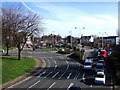
Friar's Green, Exeter
A somewhat complex roundabout system at the southeastern side of the city centre, at the point where the city walls have been breached to allow Western Way (foreground) and South Street (left) through. The building beyond the traffic islands and car park is the Hotel Barcelona (Image). To its left are the buildings in Image, and to the left of these, behind the trees, is the Southgate Hotel, close to the site of the South Gate of the city.
Image: © Derek Harper
Taken: 14 Feb 2007
0.01 miles
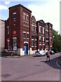
2
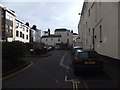
Old and new buildings in Friars Gate
Two small old buildings hidden by the taller modern block to the left in the cul-de-sac.
Image: © David Smith
Taken: 27 Jan 2014
0.01 miles
3
New Theatre, Exeter
A view of Image from the other side, showing the Venetian window in the northeast facade.
Image: © Derek Harper
Taken: 5 Jun 2006
0.02 miles
4
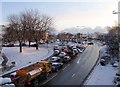
Friar's Green, Exeter
Like Image, taken from Image, but on a snowy morning. The apparently precarious seagull and light on the right are in fact supported by a lamppost.
Image: © Derek Harper
Taken: 3 Feb 2009
0.02 miles
5
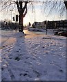
Snow on Friar's Green, Exeter
A view of part of the junction shown in Image Cars wait at the lights on Western Way. The sun is shining from the direction of Holloway Street.
Image: © Derek Harper
Taken: 3 Feb 2009
0.02 miles

7
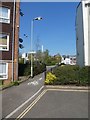
Cycle/foot path from Friars Walk to Holloway Street, Exeter
Image: © David Smith
Taken: 10 Apr 2020
0.03 miles
8
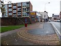
South Gate and South Street, Exeter
Part of the city walls is on the left. The pattern on the pavement shows the outline of the bastion of the South Gate through the walls into the city. The gate was demolished in the early 19th century. The tower of the Roman Catholic church is on the skyline
Image: © David Smith
Taken: 8 Nov 2013
0.03 miles
9
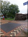
City walls and site of South Gate, Exeter
The pattern in the pavement marks the outline of part of the South Gate of the city of Exeter. Beyond is a section of wall, with traffic on the inner by-pass of the city
Image: © David Smith
Taken: 8 Nov 2013
0.03 miles
10
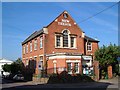
Salvation Army Temple, Friars Gate, Exeter
The Salvation Army were invited to Exeter in 1881 by Ernest Stear, a Methodist preacher with a temperance chapel in Friars Walk, then in the West Quarter, a very poor and slummy district of the city where alcoholism was rife. The chapel was soon replaced by the Exeter Temple, which was decorated with crenellated battlements, since removed. The early years of the revival movement were characterised by violent attacks on the revivalists by a 'Skeleton Army' of criminals recruited by publicans and brewers, who saw their trade threatened by the temperance message, with the collusion of the city authorities, who preferred to testify against and imprison the Salvationists. http://www.exetermemories.co.uk/em/_organisations/salvationarmy.php
Image: © A J Paxton
Taken: 23 Jun 2021
0.03 miles