IMAGES TAKEN NEAR TO
EX2 4BT
Introduction
This page details the photographs taken nearby to EX2 4BT by members of the Geograph project.
The Geograph project started in 2005 with the aim of publishing, organising and preserving representative images for every square kilometre of Great Britain, Ireland and the Isle of Man.

There are currently over 7.5m images from over14,400 individuals and you can help contribute to the project by visiting https://www.geograph.org.uk
Image Map (Loading...)


Getting Data...Please wait
Leaflet Map data © OpenStreetMap
Images are licensed for reuse under creativecommons.org/licenses/by-sa/2.0
Notes
- Clicking on the map will re-center to the selected point.
- The higher the marker number, the further away the image location is from the centre of the postcode.
Image Listing (495 Images Found)
Images are licensed for reuse under creativecommons.org/licenses/by-sa/2.0
Image
Details
Distance
1
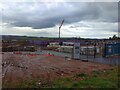
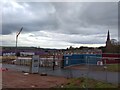
Building site, St Leonard's, Exeter
The site of the former Deaf Academy Image being developed for housing
Image: © David Smith
Taken: 25 Dec 2022
0.03 miles
2
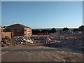
Rubble at demolition of Exeter Deaf Academy
Image: © David Smith
Taken: 30 May 2020
0.03 miles
3
Demolition of Exeter Deaf Academy and surviving bridge
The bridge crosses Topsham Road; it links the school site with the playing field
Image: © David Smith
Taken: 30 May 2020
0.04 miles
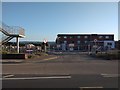
5
Building site, St Leonard's, Exeter
Part of the former Deaf Academy Image being developed for housing. The spire of St Leonard's church is on the right. Just after midday on a wet Christmas Day
Image: © David Smith
Taken: 25 Dec 2022
0.04 miles
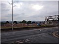
6
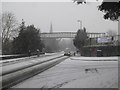
Topsham Road, Exeter, in snow
On March 1st, the Met Office put out a Red Alert for severe weather to East Devon including Exeter. The footbridge links the school and its playing field Image
Image: © David Smith
Taken: 1 Mar 2018
0.05 miles
7

Exeter St Leonard's and Exe Valley
A view from Exeter Cathedral roof looking towards St Leonard's Church and the valley of the river Exe, with a distant glimpse on the left of the river's estuary.
Image: © David Smith
Taken: Unknown
0.06 miles
8
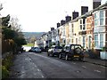
Weirfield Road, Exeter; terraced houses
As this is a residential street, the nearest car number has been blurred
Image: © David Smith
Taken: 20 Dec 2019
0.06 miles
9
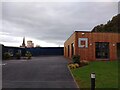
Marketing suite for housing development, St Leonard's, Exeter
Image: © David Smith
Taken: 25 Dec 2022
0.06 miles
10
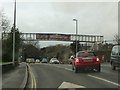
Exeter : Topsham Road
Topsham Road in Exeter heading underneath the footbridge.
Image: © Lewis Clarke
Taken: 2 Jan 2013
0.06 miles