IMAGES TAKEN NEAR TO
Commercial Road, EXETER, EX2 4AE
Introduction
This page details the photographs taken nearby to Commercial Road, EX2 4AE by members of the Geograph project.
The Geograph project started in 2005 with the aim of publishing, organising and preserving representative images for every square kilometre of Great Britain, Ireland and the Isle of Man.

There are currently over 7.5m images from over14,400 individuals and you can help contribute to the project by visiting https://www.geograph.org.uk
Image Map (Loading...)


Getting Data...Please wait
Leaflet Map data © OpenStreetMap
Images are licensed for reuse under creativecommons.org/licenses/by-sa/2.0
Notes
- Clicking on the map will re-center to the selected point.
- The higher the marker number, the further away the image location is from the centre of the postcode.
Image Listing (1017 Images Found)
Images are licensed for reuse under creativecommons.org/licenses/by-sa/2.0
Image
Details
Distance
1
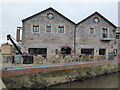
Lowered flow in Exe and leat, quayside buildings
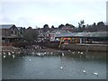
In February 2008, the Environment Agency carried out survey and dredging work on the River Exe between Millers Bridge (SX914926) and Trews Weir (SX924915) which meant that the river level was lowered by between 1 and 2 metres. This is one of a set of pictures showing the river in such unusual circumstances. The pictures of the quay form a panorama showing some of the bedrock on which the quay was built.
The leat was also being dredged
Image: © David Smith
Taken: 15 Feb 2008
0.01 miles
3
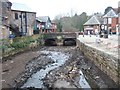
Stream bed, former leat, Exeter quay with road bridge
In February 2008, the Environment Agency carried out survey and dredging work on the River Exe between Millers Bridge (SX914926) and Trews Weir (SX924915) which meant that the river level was lowered by between 1 and 2 metres. This is one of a set of pictures showing the river in such unusual circumstances. The pictures of the quay form a panorama showing some of the bedrock on which the quay was built.
Here is the stream bed of one leat with reduced flow
Image: © David Smith
Taken: 15 Feb 2008
0.01 miles
4
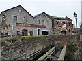
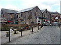
Former warehouses, Exeter
On the Quay and near Cricklepit Mill.
Image: © Chris Allen
Taken: 25 Jan 2015
0.01 miles
5
Former warehouses, Commercial Road, Exeter
The large grey one was built for Samuel Jones in 1878. Apparently being renovated at the time.
The smaller red-brick effort next door is worth a closer look Image
Image: © Stephen Richards
Taken: 18 Jun 2014
0.01 miles
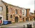
6

Converted store buildings in Commercial Street, off Exeter Quay
Image: © David Gearing
Taken: 7 Apr 2010
0.01 miles
7

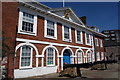
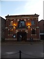
Former warehouse, Commercial Road, Exeter
It bears the words, "Kennaway & Co Limited / Bonded Stores" and is dated 1892. Listed "because it has an unusually lavish show front with good architectural detail". (Pity I turned up during a commercial vehicle convention.) Grade II listed.
It was a restaurant at the time, but has since been converted into seven flats.
Image: © Stephen Richards
Taken: 18 Jun 2014
0.01 miles
8
Bar and restaurant, Exeter
A former bonded warehouse now in use as a bar and restaurant. Note the fake crane to the left.
Image: © Chris Allen
Taken: 25 Jan 2015
0.01 miles
9
Former bonded store near Exeter Quay
The former bonded store of Kennaway and Co Ltd is now a cafe-bar with music
Image: © David Smith
Taken: 20 Nov 2011
0.01 miles
10
Exeter, Kennaway
Former bonded stores on Commercial Road, Quayside, dated 1892; now café bar. https://thelounges.co.uk/puerto/
Image: © Mike Faherty
Taken: 5 Nov 2018
0.01 miles