IMAGES TAKEN NEAR TO
COLYTON, EX24 6SJ
Introduction
This page details the photographs taken nearby to EX24 6SJ by members of the Geograph project.
The Geograph project started in 2005 with the aim of publishing, organising and preserving representative images for every square kilometre of Great Britain, Ireland and the Isle of Man.

There are currently over 7.5m images from over14,400 individuals and you can help contribute to the project by visiting https://www.geograph.org.uk
Image Map (Loading...)


Getting Data...Please wait
Leaflet Map data © OpenStreetMap
Images are licensed for reuse under creativecommons.org/licenses/by-sa/2.0
Notes
- Clicking on the map will re-center to the selected point.
- The higher the marker number, the further away the image location is from the centre of the postcode.
Image Listing (15 Images Found)
Images are licensed for reuse under creativecommons.org/licenses/by-sa/2.0
Image
Details
Distance
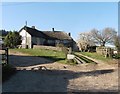
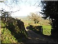
2

Downhaye, NW of Colyton, Devon
View across farmland and the Axe Valley.
Image: © Stuart Buchan
Taken: 10 May 2006
0.09 miles
4
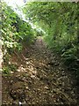
Downhayne Brake Road
A little further down the green lane shown in Image], still very stony and with trees overhanging on the right.
Image: © Derek Harper
Taken: 28 Aug 2012
0.14 miles
5
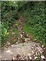
Downhayne Brake Road
From close to the point where Image] was taken. Here the path descends more steeply, with trees overhanging, and has become gullied. Rubble has been dumped, so that care is required.
Image: © Derek Harper
Taken: 28 Aug 2012
0.15 miles
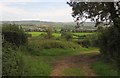
7

Towards the Umborne Brook valley
From the opening on the left of http://www.vogue.co.uk/blogs/savannah-miller, at the very corner of Downhayne Brake. The distinctive low wooded hilltop at Langdown Plantation right of centre is across the Umborne Brook valley; beyond this, in the distance, is the Axe valley. Cattle graze in the foreground pasture.
Image: © Derek Harper
Taken: 28 Aug 2012
0.16 miles
8
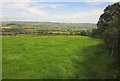
Field beside Downhayne Brake Road
From the green lane shown in Image], looking towards the valleys of the Gittshayne Goyle and the Umborne Brook.
Image: © Derek Harper
Taken: 28 Aug 2012
0.17 miles
9
Green lane junction near Red Cross
This green lane just east of Red Cross divides here, a left fork heading for Tritchayne, while right goes down to the Coly valley. There are also four gates into fields around this triangular junction, two of which can be seen here. Ahead can be seen part of Colyton.
Image: © Derek Harper
Taken: 28 Aug 2012
0.17 miles
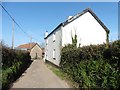
10
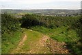
Fork in the lanes, Downhayne Brake Road
This is really a detail of the scene in Image], with the green lane bending right, and the branch to the left dropping into Downhayne Farm. Most wheeled traffic goes that way, but the public access route keeps right. Colyton is again visible over the hedges.
Image: © Derek Harper
Taken: 28 Aug 2012
0.18 miles