IMAGES TAKEN NEAR TO
Southleigh, COLYTON, EX24 6SD
Introduction
This page details the photographs taken nearby to EX24 6SD by members of the Geograph project.
The Geograph project started in 2005 with the aim of publishing, organising and preserving representative images for every square kilometre of Great Britain, Ireland and the Isle of Man.

There are currently over 7.5m images from over14,400 individuals and you can help contribute to the project by visiting https://www.geograph.org.uk
Image Map
Images are licensed for reuse under creativecommons.org/licenses/by-sa/2.0
Notes
- Clicking on the map will re-center to the selected point.
- The higher the marker number, the further away the image location is from the centre of the postcode.
Image Listing (10 Images Found)
Images are licensed for reuse under creativecommons.org/licenses/by-sa/2.0
Image
Details
Distance
1
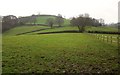
Farmland near Scruel Barton
Climbing a steep hill, the upper part of which is in Image, and seen from the lane between Southleigh and Northleigh.
Image: © Derek Harper
Taken: 5 Dec 2012
0.19 miles
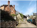
5
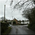
Road junction in Southleigh, and bridge over stream
Image: © David Smith
Taken: 6 Jan 2023
0.23 miles
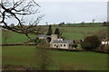
6
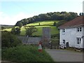
St Lawrence Church, Southleigh
The village church nestles in the stream valley; Southleigh Hills are beyond
Image: © David Smith
Taken: 25 Sep 2012
0.24 miles
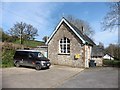
7

Shortlands Cross, Southleigh
Named after the nearby farm.
Image: © Anthony Vosper
Taken: 17 May 2012
0.24 miles
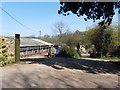
8
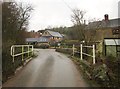
Southleigh
A winter view of Image There has been some severe flooding here recently.
Image: © Derek Harper
Taken: 5 Dec 2012
0.25 miles
9
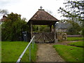
St Laurence church, lych gate
Lych is an Old English word for corpse. It was here that the burial party would rest and wait for the priest to escort them to the church.
Image: © Anthony Vosper
Taken: 17 May 2012
0.25 miles
10
Southleigh Church
And part of the village. Taken from the road which leads on to Blackbury Camp.
Image: © Trevor Harris
Taken: 27 Mar 2015
0.25 miles