IMAGES TAKEN NEAR TO
Southleigh, COLYTON, EX24 6SA
Introduction
This page details the photographs taken nearby to EX24 6SA by members of the Geograph project.
The Geograph project started in 2005 with the aim of publishing, organising and preserving representative images for every square kilometre of Great Britain, Ireland and the Isle of Man.

There are currently over 7.5m images from over14,400 individuals and you can help contribute to the project by visiting https://www.geograph.org.uk
Image Map
Images are licensed for reuse under creativecommons.org/licenses/by-sa/2.0
Notes
- Clicking on the map will re-center to the selected point.
- The higher the marker number, the further away the image location is from the centre of the postcode.
Image Listing (25 Images Found)
Images are licensed for reuse under creativecommons.org/licenses/by-sa/2.0
Image
Details
Distance
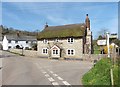


4

Southleigh Village, Devon
Southleigh is located within East Devon local authority area. Historically it formed part of Colyton Hundred.
Image: © Stuart Buchan
Taken: 10 May 2006
0.01 miles
5

Communications the old fashioned way in East Devon
The village of Southleigh still has a telephone box, a post box, and a notice board.
They also have electricity as well,note the danger of death sign on the pole.
Image: © Anthony Vosper
Taken: 17 May 2012
0.02 miles
6
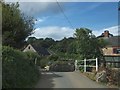
Bridge over stream in Southleigh
The stream is a tributary of the River Coly.
Image: © David Smith
Taken: 25 Sep 2012
0.02 miles
7
Southleigh
A winter view of Image There has been some severe flooding here recently.
Image: © Derek Harper
Taken: 5 Dec 2012
0.03 miles
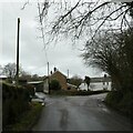
8

Shortlands Cross, Southleigh
Named after the nearby farm.
Image: © Anthony Vosper
Taken: 17 May 2012
0.04 miles
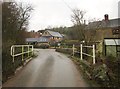
9
Road junction in Southleigh, and bridge over stream
Image: © David Smith
Taken: 6 Jan 2023
0.05 miles
10

Stream at Southleigh
A view upstream from the bridge seen in Image This is referred to as the "Southleigh rill" by W H H Rogers in his 1888 work "Memorials of the west, historical and descriptive". On the slopes of the Southleigh Hills are Birch Wood (left) and the Great Shrubbery.
Image: © Derek Harper
Taken: 5 Dec 2012
0.06 miles