IMAGES TAKEN NEAR TO
Southleigh, COLYTON, EX24 6RY
Introduction
This page details the photographs taken nearby to EX24 6RY by members of the Geograph project.
The Geograph project started in 2005 with the aim of publishing, organising and preserving representative images for every square kilometre of Great Britain, Ireland and the Isle of Man.

There are currently over 7.5m images from over14,400 individuals and you can help contribute to the project by visiting https://www.geograph.org.uk
Image Map (Loading...)


Getting Data...Please wait
Leaflet Map data © OpenStreetMap
Images are licensed for reuse under creativecommons.org/licenses/by-sa/2.0
Notes
- Clicking on the map will re-center to the selected point.
- The higher the marker number, the further away the image location is from the centre of the postcode.
Image Listing (8 Images Found)
Images are licensed for reuse under creativecommons.org/licenses/by-sa/2.0
Image
Details
Distance
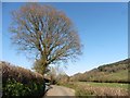
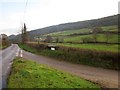
3
Morganhayes Cross
From a grass triangle where this farm road, which quickly divides towards Jobbleshayes Farm and Morganhayes Farm, leaves Southleigh Road. Morganhayes Covert is the wood on the hill in the background.
Image: © Derek Harper
Taken: 5 Dec 2012
0.08 miles
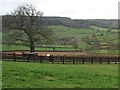
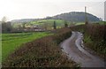
4
Valley at Morganhayes
Taken from the same spot as Image], looking to the left down the valley of a quite long but apparently unnamed tributary of the Coly. The public byway sign indicates Colyton Byway 20 leading past Jobbleshayes Farm, which is advertising free range eggs here. Cottshayne Hill is the wooded hill.
Image: © Derek Harper
Taken: 5 Dec 2012
0.13 miles
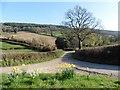
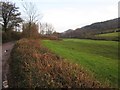
5
Southleigh Road
The lane along the valley of an unnamed tributary of the Coly winds towards Morganhayes Farm. Behind is Birch Wood on the Southleigh Hills.
Image: © Derek Harper
Taken: 5 Dec 2012
0.19 miles
6
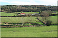
Colyton: towards Jobbleshayes Farm
Looking south-south-east from the Southleigh Road. The Forestry Commission’s Morganhayes plantation stands on the hill above.
Image: © Martin Bodman
Taken: 1 Mar 2007
0.21 miles
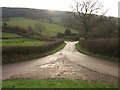
7
Southleigh Road
Looking in the other direction from the point where Image] was taken.
Image: © Derek Harper
Taken: 5 Dec 2012
0.21 miles