IMAGES TAKEN NEAR TO
St. Andrews Square, COLYTON, EX24 6JN
Introduction
This page details the photographs taken nearby to St. Andrews Square, EX24 6JN by members of the Geograph project.
The Geograph project started in 2005 with the aim of publishing, organising and preserving representative images for every square kilometre of Great Britain, Ireland and the Isle of Man.

There are currently over 7.5m images from over14,400 individuals and you can help contribute to the project by visiting https://www.geograph.org.uk
Image Map
Images are licensed for reuse under creativecommons.org/licenses/by-sa/2.0
Notes
- Clicking on the map will re-center to the selected point.
- The higher the marker number, the further away the image location is from the centre of the postcode.
Image Listing (186 Images Found)
Images are licensed for reuse under creativecommons.org/licenses/by-sa/2.0
Image
Details
Distance
4
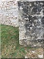
OS Cut Mark: Colyton, St Andrews Church
OS Cut Mark: Colyton, St Andrews Church
Nice example on buttress of church
Image: © thejackrustles
Taken: 20 Jul 2018
0.02 miles
6
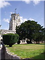
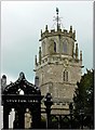
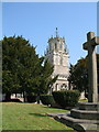
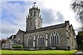
St Andrew's Church, Colyton
The Church of St Andrew dates from Norman times. Its lantern tower is one of only three in the country and was used to guide ships up the River Axe Estuary. The interior of the church is well worth a visit.
Image: © Jennifer Romero
Taken: Unknown
0.03 miles
7

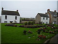
View of Colyton from the tramway terminus
Image: © Sarah Charlesworth
Taken: 2 May 2009
0.03 miles
9
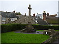
Remembering the fallen
Colyton War Memorial in the grounds of the parish church.
Image: © Anthony Vosper
Taken: 30 Dec 2011
0.03 miles
10
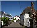
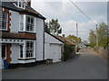
Rosemary Lane, Colyton
The route taken by the East Devon Way across the north side of the little town. On the right is The Foundry, a listed cottage that once adjoined a foundry http://list.english-heritage.org.uk/resultsingle.aspx?uid=1306116&searchtype=mapsearch .
Image: © Derek Harper
Taken: 19 Jun 2012
0.03 miles