IMAGES TAKEN NEAR TO
Farway, COLYTON, EX24 6EG
Introduction
This page details the photographs taken nearby to EX24 6EG by members of the Geograph project.
The Geograph project started in 2005 with the aim of publishing, organising and preserving representative images for every square kilometre of Great Britain, Ireland and the Isle of Man.

There are currently over 7.5m images from over14,400 individuals and you can help contribute to the project by visiting https://www.geograph.org.uk
Image Map (Loading...)


Getting Data...Please wait
Leaflet Map data © OpenStreetMap
Images are licensed for reuse under creativecommons.org/licenses/by-sa/2.0
Notes
- Clicking on the map will re-center to the selected point.
- The higher the marker number, the further away the image location is from the centre of the postcode.
Image Listing (7 Images Found)
Images are licensed for reuse under creativecommons.org/licenses/by-sa/2.0
Image
Details
Distance
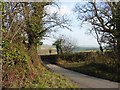
3
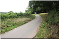
Sandpit Hill
Sandpit Hill is the minor road that leads up the north slopes of Farway Hill from Church Green through Devenish Pitt Farm to the ridge on top of Farway Hill.
Image: © Nigel Mykura
Taken: 13 Jul 2019
0.10 miles
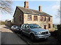
4
Countryside near Devenish Pit Farm
A view from Sallicombe Road.
Image: © Derek Harper
Taken: 20 May 2011
0.11 miles
5
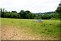
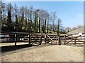
Field at Devenish Pitt Farm
This is a pasture field complete with cattle fodder feeder on the lower slopes of Sandpit Hill between the farm and Tedbridge..
Image: © Nigel Mykura
Taken: 13 Jul 2019
0.14 miles
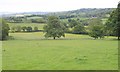
7
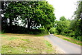
Sandpit Hill
This is the twisty minor road that is a very steep hill leading down from Farway Hill to Devenish Pitt Farm and Church Green.
Image: © Nigel Mykura
Taken: 13 Jul 2019
0.25 miles