IMAGES TAKEN NEAR TO
Farway, COLYTON, EX24 6DH
Introduction
This page details the photographs taken nearby to EX24 6DH by members of the Geograph project.
The Geograph project started in 2005 with the aim of publishing, organising and preserving representative images for every square kilometre of Great Britain, Ireland and the Isle of Man.

There are currently over 7.5m images from over14,400 individuals and you can help contribute to the project by visiting https://www.geograph.org.uk
Image Map
Images are licensed for reuse under creativecommons.org/licenses/by-sa/2.0
Notes
- Clicking on the map will re-center to the selected point.
- The higher the marker number, the further away the image location is from the centre of the postcode.
Image Listing (2 Images Found)
Images are licensed for reuse under creativecommons.org/licenses/by-sa/2.0
Image
Details
Distance
1
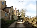
Holnest Farm
Underneath the pebbledash is a farm of some age, although it was much altered in the C19. The tiny lane beside it, Hornshayne Lane, rambles along the side of the Coly valley for almost a mile before finishing up at Image
Image: © Derek Harper
Taken: 2 Apr 2007
0.14 miles