IMAGES TAKEN NEAR TO
Stratton, BUDE, EX23 9TE
Introduction
This page details the photographs taken nearby to EX23 9TE by members of the Geograph project.
The Geograph project started in 2005 with the aim of publishing, organising and preserving representative images for every square kilometre of Great Britain, Ireland and the Isle of Man.

There are currently over 7.5m images from over14,400 individuals and you can help contribute to the project by visiting https://www.geograph.org.uk
Image Map
Images are licensed for reuse under creativecommons.org/licenses/by-sa/2.0
Notes
- Clicking on the map will re-center to the selected point.
- The higher the marker number, the further away the image location is from the centre of the postcode.
Image Listing (5 Images Found)
Images are licensed for reuse under creativecommons.org/licenses/by-sa/2.0
Image
Details
Distance
2
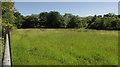
Meadow, Howard
A bocage feel about this field, seen from a gateway on Howard Lane. The right-hand side of the field is in Image
Image: © Derek Harper
Taken: 21 Jun 2019
0.13 miles
3

Meadow, Howard
Looking the othr way from the gate where Image] was taken, this time with the view crossing into Image
Image: © Derek Harper
Taken: 21 Jun 2019
0.18 miles
4
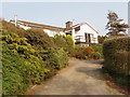
House at Howard
View from road. The grid line runs along the road here.
Image: © David Hawgood
Taken: 16 Apr 2007
0.20 miles
5

Track to pumping station
View from road by Howard.
Image: © David Hawgood
Taken: 16 Apr 2007
0.21 miles