IMAGES TAKEN NEAR TO
Morwenstow, BUDE, EX23 9ST
Introduction
This page details the photographs taken nearby to EX23 9ST by members of the Geograph project.
The Geograph project started in 2005 with the aim of publishing, organising and preserving representative images for every square kilometre of Great Britain, Ireland and the Isle of Man.

There are currently over 7.5m images from over14,400 individuals and you can help contribute to the project by visiting https://www.geograph.org.uk
Image Map
Images are licensed for reuse under creativecommons.org/licenses/by-sa/2.0
Notes
- Clicking on the map will re-center to the selected point.
- The higher the marker number, the further away the image location is from the centre of the postcode.
Image Listing (3 Images Found)
Images are licensed for reuse under creativecommons.org/licenses/by-sa/2.0
Image
Details
Distance
1
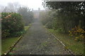
Marsland Manor
Marsland manor viewed from the entrance.
Image: © Philip Halling
Taken: 15 Apr 2007
0.03 miles
2
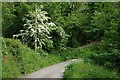
Lane through the Valley
A country land approaches the valley bottom near Marsland Manor.
Image: © Tony Atkin
Taken: 30 May 2010
0.16 miles
3

Gate towards the South West Coast Path
This gated track leads eventually to that path.
Image: © Julian P Guffogg
Taken: 23 Sep 2015
0.17 miles