IMAGES TAKEN NEAR TO
St. Davids Close, BUDE, EX23 9JP
Introduction
This page details the photographs taken nearby to St. Davids Close, EX23 9JP by members of the Geograph project.
The Geograph project started in 2005 with the aim of publishing, organising and preserving representative images for every square kilometre of Great Britain, Ireland and the Isle of Man.

There are currently over 7.5m images from over14,400 individuals and you can help contribute to the project by visiting https://www.geograph.org.uk
Image Map
Images are licensed for reuse under creativecommons.org/licenses/by-sa/2.0
Notes
- Clicking on the map will re-center to the selected point.
- The higher the marker number, the further away the image location is from the centre of the postcode.
Image Listing (3 Images Found)
Images are licensed for reuse under creativecommons.org/licenses/by-sa/2.0
Image
Details
Distance
1

Woodford village
From Cannapark Wood.
Image: © Nick Chipchase
Taken: 1 Jan 2021
0.15 miles
2
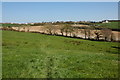
Farmland to the west of Woodford
A footpath crosses this land between Eastaway Manor and Woodford. Shears Farm can be seen to the right.
Image: © Philip Halling
Taken: 19 Apr 2007
0.23 miles
3

Woodford from the East
This image shows the chapel.
Image: © Nick Chipchase
Taken: 1 Jan 2021
0.24 miles