IMAGES TAKEN NEAR TO
Woodford, BUDE, EX23 9JL
Introduction
This page details the photographs taken nearby to EX23 9JL by members of the Geograph project.
The Geograph project started in 2005 with the aim of publishing, organising and preserving representative images for every square kilometre of Great Britain, Ireland and the Isle of Man.

There are currently over 7.5m images from over14,400 individuals and you can help contribute to the project by visiting https://www.geograph.org.uk
Image Map
Images are licensed for reuse under creativecommons.org/licenses/by-sa/2.0
Notes
- Clicking on the map will re-center to the selected point.
- The higher the marker number, the further away the image location is from the centre of the postcode.
Image Listing (4 Images Found)
Images are licensed for reuse under creativecommons.org/licenses/by-sa/2.0
Image
Details
Distance
1
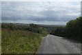
Road dropping towards Coombe
On the left is the end of the track to Ovis; the road drops into the valley, and the land rises to another flat cliff-top
Image: © David Smith
Taken: 21 Aug 2019
0.10 miles

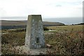
4

Morwenstow Satellite Station
View of Morwenstow Satellite Station from across Coombe Valley in Image
Image: © Bob Parkes
Taken: 12 May 2003
0.17 miles