IMAGES TAKEN NEAR TO
Woodford, BUDE, EX23 9HR
Introduction
This page details the photographs taken nearby to EX23 9HR by members of the Geograph project.
The Geograph project started in 2005 with the aim of publishing, organising and preserving representative images for every square kilometre of Great Britain, Ireland and the Isle of Man.

There are currently over 7.5m images from over14,400 individuals and you can help contribute to the project by visiting https://www.geograph.org.uk
Image Map
Images are licensed for reuse under creativecommons.org/licenses/by-sa/2.0
Notes
- Clicking on the map will re-center to the selected point.
- The higher the marker number, the further away the image location is from the centre of the postcode.
Image Listing (6 Images Found)
Images are licensed for reuse under creativecommons.org/licenses/by-sa/2.0
Image
Details
Distance
1
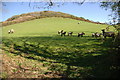
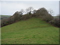
Pasture to the North West of Penstowe (Kilkhampton) Castle
The site of Penstowe (Kilkhampton) Castle is situated to the west of the village of Kilkhampton. The castle is out of sight behind the trees at the top of the pasture. The fortification was probably built illegally during the 12th century civil war. Today little remains other than a motte, two baileys, plus associated earthworks.
Image: © Philip Halling
Taken: 19 Apr 2007
0.16 miles
2
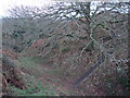
Penstowe Castle near Kilkhampton
Ditch between inner bailey and the motte. Modern day access to the motte is via the dark zig-zag path. In medieval times there would probably have been a wooden bridge.
Image: © John Duncan
Taken: 30 Dec 2007
0.16 miles
3
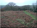
Penstowe Castle near Kilkhampton
View looking west over the inner bailey towards the motte that can be seen as the mound behind the tree in the near background.
Image: © John Duncan
Taken: 30 Dec 2007
0.18 miles
4
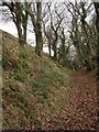
Penstowe Castle near Kilkhampton
View along the boundary ditch on the northern side of the castle site.
Image: © John Duncan
Taken: 30 Dec 2007
0.18 miles
5
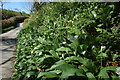
Wild Garlic in Coombe Valley
Ramson, (Allium ursinum) or wild garlic and Wood Anemones growing on the banks of a lane in Coombe Valley.
Image: © Philip Halling
Taken: 18 Apr 2007
0.22 miles
6
Penstowe Castle near Kilkhampton
View of the eastern end of the main site from the footpath entrance to the field. The mound in this photo is a natural feature, augmented by earthworks. The inner and outer baileys and motte are obscured by the trees.
Image: © John Duncan
Taken: 30 Dec 2007
0.22 miles