IMAGES TAKEN NEAR TO
Stamford Hill, BUDE, EX23 9AY
Introduction
This page details the photographs taken nearby to Stamford Hill, EX23 9AY by members of the Geograph project.
The Geograph project started in 2005 with the aim of publishing, organising and preserving representative images for every square kilometre of Great Britain, Ireland and the Isle of Man.

There are currently over 7.5m images from over14,400 individuals and you can help contribute to the project by visiting https://www.geograph.org.uk
Image Map
Images are licensed for reuse under creativecommons.org/licenses/by-sa/2.0
Notes
- Clicking on the map will re-center to the selected point.
- The higher the marker number, the further away the image location is from the centre of the postcode.
Image Listing (12 Images Found)
Images are licensed for reuse under creativecommons.org/licenses/by-sa/2.0
Image
Details
Distance
1

Business site by A39 north of Stratton
A plumbers' merchants and car wash in the valley of the River Strat
Image: © David Smith
Taken: 14 Apr 2016
0.06 miles
2
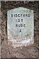
Old Milestone north of Stratton
Carved stone post in parish of STRATTON (NORTH CORNWALL District), on line of old main road, North West of Townsend, set into bank opposite farm gateway, 50m South of house drive, on East side of road. Gravestone, erected by the Local Highways Board in the 19th century.
Inscription reads:-
BIDEFORD
23
BUDE
2
Milestone Society National ID: CW_BUBF02.
Image: © Ian Thompson
Taken: 7 Jun 2011
0.18 miles
3
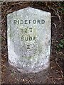
Old Milestone north of Stratton
Carved stone post in parish of STRATTON (NORTH CORNWALL District), on line of old main road, Northwest of Townsend, set into bank opposite Farm gateway, 50m South of house drive, on East side of road. Gravestone, erected by the Local Highways Board in the 19th century.
Inscription reads:-
BIDEFORD
23
BUDE
2
Cornwall & Scilly HER.
HER Number: 178414 https://www.heritagegateway.org.uk/Gateway/Results_Single.aspx?uid=MCO54190&resourceID=1020
Milestone Society National ID: CW_BUBF02.
Image: © Rosy Hanns
Taken: 5 Jun 2019
0.18 miles
4
Site of the Battle of Stratton
The English Civil War battle took place on 16 May 1643. See: http://www.battlefieldstrust.com/resource-centre/civil-war/battleview.asp?BattleFieldId=44
Image: © Philip Halling
Taken: 17 Apr 2007
0.18 miles
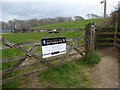
5
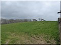
Field, part of the site of the Battle of Stamford Hill in 1643
Image: © David Smith
Taken: 15 Apr 2016
0.19 miles
6
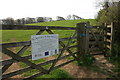
Sign for Stamford Hill Battle Site
Site of one of the key battles of the English Civil War in 1643
Image: © David Smith
Taken: 15 Apr 2016
0.20 miles
7

Ward Close, Stratton
A modern cul-de-sac; not sure if the name is because the local hospital is nearby
Image: © David Smith
Taken: 14 Apr 2016
0.22 miles

9

Maiden Street, Stratton
The Methodist Church is on the left.
Image: © Humphrey Bolton
Taken: 7 May 2009
0.23 miles
10

Fields, part of the site of the battle of Stamford Hill
Image: © David Smith
Taken: 15 Apr 2016
0.24 miles