IMAGES TAKEN NEAR TO
Kollen Drive, EX23 8TN
Introduction
This page details the photographs taken nearby to Kollen Drive, EX23 8TN by members of the Geograph project.
The Geograph project started in 2005 with the aim of publishing, organising and preserving representative images for every square kilometre of Great Britain, Ireland and the Isle of Man.

There are currently over 7.5m images from over14,400 individuals and you can help contribute to the project by visiting https://www.geograph.org.uk
Image Map (Loading...)


Getting Data...Please wait
Leaflet Map data © OpenStreetMap
Images are licensed for reuse under creativecommons.org/licenses/by-sa/2.0
Notes
- Clicking on the map will re-center to the selected point.
- The higher the marker number, the further away the image location is from the centre of the postcode.
Image Listing (195 Images Found)
Images are licensed for reuse under creativecommons.org/licenses/by-sa/2.0
Image
Details
Distance
2

The Strand
Line of shops and other business on The Strand.
Image: © Ian Capper
Taken: 12 Sep 2017
0.01 miles
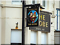
3

The Globe
Hotel on The Strand, formerly a pub "The Jolly Sailor", although it is already shown with its current name on the 1884-5 1:2500 map.
Image: © Ian Capper
Taken: 12 Sep 2017
0.02 miles
4
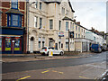
The Globe Hotel, Bude
Currently closed but in anticipation of refurbishment and a new occupant.
Image: © John Lucas
Taken: 23 Nov 2022
0.02 miles
5

The Strand
Line of shops and other business on The Strand.
Image: © Ian Capper
Taken: 12 Sep 2017
0.02 miles
6

Bude : The Carriers Inn
The Carriers Inn is a pub in the centre of Bude.
Image: © Lewis Clarke
Taken: 23 Feb 2020
0.02 miles

8
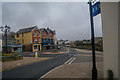
Bude : The Strand
Looking along The Strand.
Image: © Lewis Clarke
Taken: 23 Feb 2020
0.03 miles
9

The Carriers Inn
Originally a 17th Century manor farmhouse, now a pub.
Image: © Ian Capper
Taken: 12 Sep 2017
0.03 miles
10
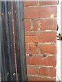
OS benchmark - Bude, Bank at No 10, The Strand
An OS cutmark on the side wall of the bank; originally levelled at 6.516m above Ordnance Datum Newlyn in 1973.
Image: © Richard Law
Taken: 3 Oct 2017
0.04 miles