
IMAGES TAKEN NEAR TO
Flexbury Avenue, BUDE, EX23 8RE
Introduction
This page details the photographs taken nearby to Flexbury Avenue, EX23 8RE by members of the Geograph project.
The Geograph project started in 2005 with the aim of publishing, organising and preserving representative images for every square kilometre of Great Britain, Ireland and the Isle of Man.

There are currently over 7.5m images from over14,400 individuals and you can help contribute to the project by visiting https://www.geograph.org.uk
Image Map
Images are licensed for reuse under creativecommons.org/licenses/by-sa/2.0
Notes
- Clicking on the map will re-center to the selected point.
- The higher the marker number, the further away the image location is from the centre of the postcode.
Image Listing (26 Images Found)
Images are licensed for reuse under creativecommons.org/licenses/by-sa/2.0
Image
Details
Distance
1

Lake House, Flexbury, Bude
An early 19C house with an attractive iron verandah. The shop was a post office.
Image: © Humphrey Bolton
Taken: 3 May 2009
0.02 miles
2
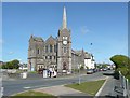
Flexbury Park Methodist Church, Bude
This was opened in March 1905, and became a United Methodist Church after the amalgamation of the Bible Christians and Free Methodists in 1908. The architect was John Pethick and the builders the Petherick Brothers, a local firm. The facing stones are of limestone, and the 24m spire is sheathed with copper. The spire was damaged by a gale in 1991, and rebuilt after much fund-raising. There are now more structural problems as c. 2008 the Environment Agency constructed a culvert close to the church, and ominous cracks have since appeared in the stonework.
Image: © Humphrey Bolton
Taken: 3 May 2009
0.02 miles
3
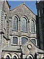
Detail, Flexbury Park Methodist Church, Bude
I like the windows with little multicoloured panes. The central vertical window-bars that do not go right to the top but finish with a fleur-de-lis look unusual.
Image: © Humphrey Bolton
Taken: 3 May 2009
0.02 miles
4
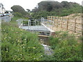
Inlet trash screen at Flexbury Park
Part of the Environment Agency Flexbury flood alleviation scheme.
Image: © Rod Allday
Taken: 18 Aug 2009
0.04 miles
5
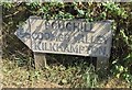
Old Direction Sign - Signpost by Flexbury Park, Bude Stratton
No finial - 1 arm; by the UC road, in parish of Bude Stratton (North Cornwall District), junction of Golf House Road, Flexbury Park and Downs View.
To be surveyed
Milestone Society National ID: CW_SS2106
Image: © Milestone Society
Taken: Unknown
0.05 miles
6
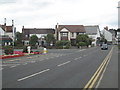
Golf House Road Flexbury
The road that leads from Bude to Flexbury. The road on the left is Downs View.
Image: © Rod Allday
Taken: 18 Aug 2009
0.05 miles
7
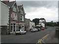
Golf House Road Flexbury
Flexbury is a mainly residential area on the outskirts of Bude.
Image: © Rod Allday
Taken: 18 Aug 2009
0.05 miles
8

Trash grid, Flexbury Park, Bude
Floodlights or fly traps?
Image: © Humphrey Bolton
Taken: 3 May 2009
0.06 miles
9
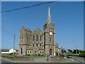
Flexbury Park Methodist Church
Opened in April 1905.
Image: © Neil Lewin
Taken: 13 Jul 2006
0.06 miles
10
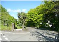
Cedar Grove, Flexbury Park, Bude
Guarded by a palm-tree rather than a cedar.
Image: © Humphrey Bolton
Taken: 3 May 2009
0.06 miles