IMAGES TAKEN NEAR TO
Swallow Close, BUDE, EX23 8PL
Introduction
This page details the photographs taken nearby to Swallow Close, EX23 8PL by members of the Geograph project.
The Geograph project started in 2005 with the aim of publishing, organising and preserving representative images for every square kilometre of Great Britain, Ireland and the Isle of Man.

There are currently over 7.5m images from over14,400 individuals and you can help contribute to the project by visiting https://www.geograph.org.uk
Image Map
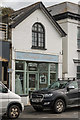
Images are licensed for reuse under creativecommons.org/licenses/by-sa/2.0
Notes
- Clicking on the map will re-center to the selected point.
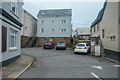
- The higher the marker number, the further away the image location is from the centre of the postcode.
Image Listing (146 Images Found)
Images are licensed for reuse under creativecommons.org/licenses/by-sa/2.0
Image
Details
Distance
1
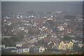
Bude : Bude Scenery
Looking down to the town of Bude.
Image: © Lewis Clarke
Taken: 23 Feb 2020
0.04 miles
2
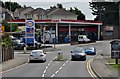
Bude : Esso Petrol Station
A petrol station on Bencoolen Road on the way in and out of Bude.
Image: © Lewis Clarke
Taken: 4 Jul 2011
0.05 miles
3
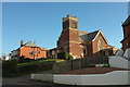
St Martin's United Reformed Church, Bude
On Killerton Road. Can anyone give a date?
Image: © Derek Harper
Taken: 19 Jan 2017
0.06 miles
4
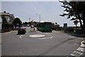
Bude : Bencoolen Road
A bus heading along Bencoolen Road on the way into Bude.
Image: © Lewis Clarke
Taken: 4 Jul 2011
0.07 miles
5

The Octagon
Buseiness and housing on The Strand. The nearest building is part of The Octagon, a 2006 development of apartments.
Image: © Ian Capper
Taken: 12 Sep 2017
0.08 miles
6

N Class 2-6-0 31874 at Bude, 1963
Running round its train. Although built for the South Eastern and Chatham Railway, this class of engine was very versatile and found its way to all parts of the former Southern Railway territory.
Image: © Alan Murray-Rust
Taken: Unknown
0.08 miles
7
Budeiful Brides
Bridal wear business on The Strand.
Image: © Ian Capper
Taken: 12 Sep 2017
0.08 miles
8

Bude bridge replacement scheme
Here Bencoolen Road has been diverted to pass over a temporary bridge over the River Neet. Construction work was planned to start on 17 September 2012 as the condition of the current bridge had deteriorated over recent years.
Cornwall Council has designed a replacement to supplement the town’s existing flood defences while being in keeping with the surrounding environment http://www.cornwall.gov.uk/default.aspx?page=32372
Image: © John Baker
Taken: 24 Mar 2013
0.08 miles
9

Bude : The River Neet
The River Neet taken from Bencoolen Road on the bridge.
Image: © Lewis Clarke
Taken: 4 Jul 2011
0.09 miles
10
Bude : Small Lane
A small lane heading around the back of businesses on The Strand.
Image: © Lewis Clarke
Taken: 23 Feb 2020
0.09 miles