IMAGES TAKEN NEAR TO
BUDE, EX23 8PA
Introduction
This page details the photographs taken nearby to EX23 8PA by members of the Geograph project.
The Geograph project started in 2005 with the aim of publishing, organising and preserving representative images for every square kilometre of Great Britain, Ireland and the Isle of Man.

There are currently over 7.5m images from over14,400 individuals and you can help contribute to the project by visiting https://www.geograph.org.uk
Image Map
Images are licensed for reuse under creativecommons.org/licenses/by-sa/2.0
Notes
- Clicking on the map will re-center to the selected point.
- The higher the marker number, the further away the image location is from the centre of the postcode.
Image Listing (8 Images Found)
Images are licensed for reuse under creativecommons.org/licenses/by-sa/2.0
Image
Details
Distance

2
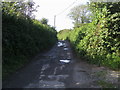
Bridleway to Mayfield
Off Poughill road bridleway to Mayfield
Image: © Shaun Ferguson
Taken: 29 Aug 2012
0.13 miles
4
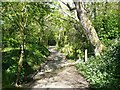
Footpath, Poughill (Bude)
This is a public footpath, perhaps an old packhorse track, from Hollabury Road to Broomhill.
Image: © Humphrey Bolton
Taken: 3 May 2009
0.20 miles
5
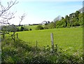
View towards Paize, Poughill
From the public footpath near Broomhill Manor.
Image: © Humphrey Bolton
Taken: 3 May 2009
0.20 miles
6
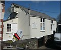
Hollabury Mission Hall, Bude
Not shown by the OS as a place of worship, but part of St Olaf's Church of Poughill.
Image: © Humphrey Bolton
Taken: 3 May 2009
0.22 miles
7
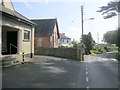
Poughill Village Hall
Poughill Village Hall (1932) next to the village Methodist Church
Image: © Shaun Ferguson
Taken: 29 Aug 2012
0.23 miles
