IMAGES TAKEN NEAR TO
Broad Close Hill, BUDE, EX23 8EA
Introduction
This page details the photographs taken nearby to Broad Close Hill, EX23 8EA by members of the Geograph project.
The Geograph project started in 2005 with the aim of publishing, organising and preserving representative images for every square kilometre of Great Britain, Ireland and the Isle of Man.

There are currently over 7.5m images from over14,400 individuals and you can help contribute to the project by visiting https://www.geograph.org.uk
Image Map
Images are licensed for reuse under creativecommons.org/licenses/by-sa/2.0
Notes
- Clicking on the map will re-center to the selected point.
- The higher the marker number, the further away the image location is from the centre of the postcode.
Image Listing (7 Images Found)
Images are licensed for reuse under creativecommons.org/licenses/by-sa/2.0
Image
Details
Distance
1

Bude : Countryside Scenery
Looking out across the countryside near Bude.
Image: © Lewis Clarke
Taken: 23 Feb 2020
0.10 miles
2

Broadclose Park
Home of Bude Town FC on Broadclose Park providing a temporary caravan park
Image: © Shaun Ferguson
Taken: 31 Aug 2012
0.13 miles
3
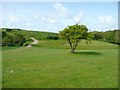
Footpath across a golf course, Bude
I had the impression that the golfers don't like having a public footpath across their course, but the path must have been there first.
Image: © Humphrey Bolton
Taken: 3 May 2009
0.21 miles
4
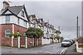
Bramble Hill
Early 20th Century housing, with the road marked in outline on the 1907 6 inch map.
Image: © Ian Capper
Taken: 29 Jan 2022
0.22 miles
5
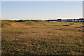
Bude and North Cornwall Golf Club
View south across the golf course towards the houses on Burn View.
Image: © Nigel Mykura
Taken: 24 May 2017
0.22 miles
6
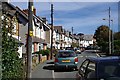
Killerton Road
A typical suburban street in Bude.
Image: © Tony Atkin
Taken: 11 Sep 2009
0.24 miles
7

Bude : The Co-Op
A Co-Op store on Burn View.
Image: © Lewis Clarke
Taken: 23 Feb 2020
0.24 miles