IMAGES TAKEN NEAR TO
Cambeak Close, BUDE, EX23 0PE
Introduction
This page details the photographs taken nearby to Cambeak Close, EX23 0PE by members of the Geograph project.
The Geograph project started in 2005 with the aim of publishing, organising and preserving representative images for every square kilometre of Great Britain, Ireland and the Isle of Man.

There are currently over 7.5m images from over14,400 individuals and you can help contribute to the project by visiting https://www.geograph.org.uk
Image Map (Loading...)


Getting Data...Please wait
Leaflet Map data © OpenStreetMap
Images are licensed for reuse under creativecommons.org/licenses/by-sa/2.0
Notes
- Clicking on the map will re-center to the selected point.
- The higher the marker number, the further away the image location is from the centre of the postcode.
Image Listing (8 Images Found)
Images are licensed for reuse under creativecommons.org/licenses/by-sa/2.0
Image
Details
Distance
1
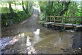
Middle Crackington Ford
This ford is found at Lansweden near Middle Crackington.
Image: © John Walton
Taken: 26 Sep 2015
0.12 miles
2
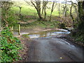
Ford on a minor road at Lansweden
This is one of the streams which flows into the sea at Crackington Haven and caused serious flooding there on 16 August 2004.
Image: © Rod Allday
Taken: 2 Apr 2010
0.12 miles
3

Cemetery gateway at Middle Crackington
Opposite Brockhill Methodist Church.
Image: © Rod Allday
Taken: 2 Apr 2010
0.14 miles
5
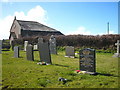
The cemetery at Brockhill Methodist Church
On top of the hill above Crackington Haven.
Image: © Rod Allday
Taken: 2 Apr 2010
0.15 miles
6
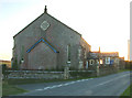
Brockhill United Methodist Church
Built 1842
Image: © Neil Lewin
Taken: 13 Jul 2006
0.15 miles
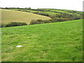
7

Grazing land at Crackington
Grazing land to the north of Crackington.
Image: © Philip Halling
Taken: 29 Sep 2009
0.16 miles
8

Cottage at Sweets nr Crackington Cornwall
Image: © Clive Perrin
Taken: 11 Sep 2005
0.24 miles