IMAGES TAKEN NEAR TO
Upton, BUDE, EX23 0LP
Introduction
This page details the photographs taken nearby to EX23 0LP by members of the Geograph project.
The Geograph project started in 2005 with the aim of publishing, organising and preserving representative images for every square kilometre of Great Britain, Ireland and the Isle of Man.

There are currently over 7.5m images from over14,400 individuals and you can help contribute to the project by visiting https://www.geograph.org.uk
Image Map
Images are licensed for reuse under creativecommons.org/licenses/by-sa/2.0
Notes
- Clicking on the map will re-center to the selected point.
- The higher the marker number, the further away the image location is from the centre of the postcode.
Image Listing (18 Images Found)
Images are licensed for reuse under creativecommons.org/licenses/by-sa/2.0
Image
Details
Distance
1
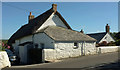
The Thatch
A listed thatched cottage https://historicengland.org.uk/listing/the-list/list-entry/1229922 sandwiched between modern houses on Lynstone Road.
Image: © Derek Harper
Taken: 21 Jun 2019
0.04 miles
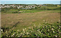
2
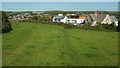
Field, Lynstone
From footpath 506 19/1 as it crosses the field from Lynstone Road (right).
Image: © Derek Harper
Taken: 21 Jun 2019
0.05 miles
3
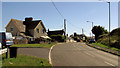
Houses, Lynstone
The thatched cottage in the centre is listed https://historicengland.org.uk/listing/the-list/list-entry/1229922 Image
Image: © Derek Harper
Taken: 21 Jun 2019
0.05 miles
4
Lane at Lynstone
Mapped as "The Grange" and leading away from Lynstone Road down into the Neet valley.
Image: © Derek Harper
Taken: 21 Jun 2019
0.09 miles
5
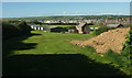
Upper Lynstone Caravan & Camping Park
Seen from footpath 506 19/1, with Bude spread out beyond, and GCHQ Bude visible on the extreme left.
Image: © Derek Harper
Taken: 21 Jun 2019
0.09 miles
6
Upper Lynstone Caravan & Camping Park
Looking right from Image], again with overlap, and with Bude beyond the campsite.
Image: © Derek Harper
Taken: 21 Jun 2019
0.12 miles
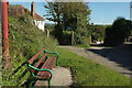
7

Gate near Lynstone
Image: © Derek Harper
Taken: 21 Jun 2019
0.13 miles
8

Lynstone Road
In the foreground is the entrance to Upper Lynstone Campsite; caravans can be seen on the left. The main road then drops towards Bude.
Image: © Derek Harper
Taken: 21 Jun 2019
0.13 miles
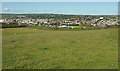
9
Towards the Neet valley
From Lynstone Road at the junction with The Grange. On the flood plain is the Bude Rugby Club Ground; beyond it is southern Bude.
Image: © Derek Harper
Taken: 21 Jun 2019
0.14 miles
10
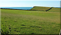
Sheep pasture, Lynstone
From footpath 506 19/1, looking towards Efford Beacon.
Image: © Derek Harper
Taken: 21 Jun 2019
0.14 miles