IMAGES TAKEN NEAR TO
Crackington Haven, BUDE, EX23 0LH
Introduction
This page details the photographs taken nearby to EX23 0LH by members of the Geograph project.
The Geograph project started in 2005 with the aim of publishing, organising and preserving representative images for every square kilometre of Great Britain, Ireland and the Isle of Man.

There are currently over 7.5m images from over14,400 individuals and you can help contribute to the project by visiting https://www.geograph.org.uk
Image Map
Images are licensed for reuse under creativecommons.org/licenses/by-sa/2.0
Notes
- Clicking on the map will re-center to the selected point.
- The higher the marker number, the further away the image location is from the centre of the postcode.
Image Listing (57 Images Found)
Images are licensed for reuse under creativecommons.org/licenses/by-sa/2.0
Image
Details
Distance
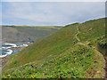
1
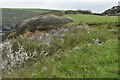
Clifftop field southwest of Crackington Haven
The coast path passes through this field around a sizeable landslip which has left fenceposts dangling in mid-air.
Image: © David Martin
Taken: 29 Apr 2023
0.04 miles
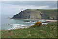
3
St Gennys: above Tremoutha Haven
Looking towards Cambeak. On the coast path from Crackington Haven
Image: © Martin Bodman
Taken: 22 Apr 2009
0.07 miles
4
St Gennys: north to Pencarrow Point
On the South West Coast Path, looking towards Crackington Haven. Pencarrow Point is also known as Penkenna Point
Image: © Martin Bodman
Taken: 22 Apr 2009
0.07 miles

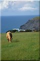
6

St Gennys: heading for Crackington Haven
On the South West Coast Path, between Cambeak and Crackington Haven
Image: © Martin Bodman
Taken: 22 Apr 2009
0.11 miles
7
The Coast Path at Brays Point Cornwall
Looking NE Crackington Haven ahead.
Image: © Clive Perrin
Taken: 11 Sep 2005
0.11 miles
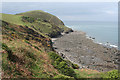
8
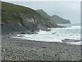
Crackington Haven, St Gennys
The beach is stony, and the coastal slope to the south lined with great slabs of rock, I think it is slate.
Image: © Humphrey Bolton
Taken: 7 May 2009
0.11 miles
9
St Gennys: steps on the coastpath
On the South West Coast Path, nearing Crackington Haven
Image: © Martin Bodman
Taken: 22 Apr 2009
0.11 miles
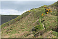
10

St Gennys: through apple and gorse
The South West Coast Path climbs up from Crackington Haven on the way to Cambeak
Image: © Martin Bodman
Taken: 22 Apr 2009
0.14 miles