IMAGES TAKEN NEAR TO
Rosecare, BUDE, EX23 0BE
Introduction
This page details the photographs taken nearby to Rosecare, EX23 0BE by members of the Geograph project.
The Geograph project started in 2005 with the aim of publishing, organising and preserving representative images for every square kilometre of Great Britain, Ireland and the Isle of Man.

There are currently over 7.5m images from over14,400 individuals and you can help contribute to the project by visiting https://www.geograph.org.uk
Image Map
Images are licensed for reuse under creativecommons.org/licenses/by-sa/2.0
Notes
- Clicking on the map will re-center to the selected point.
- The higher the marker number, the further away the image location is from the centre of the postcode.
Image Listing (4 Images Found)
Images are licensed for reuse under creativecommons.org/licenses/by-sa/2.0
Image
Details
Distance
1
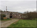
House in Rosecare
From the Green, near Rosecare Farm.
Image: © David Hawgood
Taken: 28 Feb 2008
0.06 miles
2
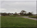
The Green at Rosecare
A very pleasant small village where the houses - which seem to be mainly holiday cottages - are grouped around a large green.
Image: © David Hawgood
Taken: 28 Feb 2008
0.09 miles
3
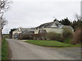
Houses at Rosecare
On the road just away from the village green.
Image: © David Hawgood
Taken: 28 Feb 2008
0.13 miles
4
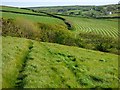
Farmland, St Gennys
On the footpath between Rosecare and Pencuke.
Image: © Andrew Smith
Taken: 12 May 2019
0.23 miles