IMAGES TAKEN NEAR TO
Dunsland Cross, HOLSWORTHY, EX22 7YT
Introduction
This page details the photographs taken nearby to Dunsland Cross, EX22 7YT by members of the Geograph project.
The Geograph project started in 2005 with the aim of publishing, organising and preserving representative images for every square kilometre of Great Britain, Ireland and the Isle of Man.

There are currently over 7.5m images from over14,400 individuals and you can help contribute to the project by visiting https://www.geograph.org.uk
Image Map
Images are licensed for reuse under creativecommons.org/licenses/by-sa/2.0
Notes
- Clicking on the map will re-center to the selected point.
- The higher the marker number, the further away the image location is from the centre of the postcode.
Image Listing (4 Images Found)
Images are licensed for reuse under creativecommons.org/licenses/by-sa/2.0
Image
Details
Distance
1
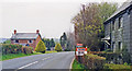
In deepest Devon by site of Dunsland Cross station, 1995
View northward on B3273, one mile south of Dunsland Cross. The station had been on the right and was on the ex-LSWR Halwill Junction - Bude line, closed 3/10/66.
Image: © Ben Brooksbank
Taken: 24 Apr 1995
0.03 miles
2
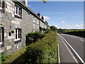
Station Cottages
This terrace of six cottages by the A3079 is beside the site of Dunsland Cross station.
Image: © Derek Harper
Taken: 7 Jul 2007
0.06 miles
3
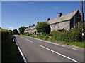
Station Cottages
A view of Image from the other side of the A3079.
Image: © Derek Harper
Taken: 7 Jul 2007
0.06 miles
4
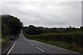
A3079 past Claw Moor Plantation
Named after the nearby River Claw.
Image: © Julian P Guffogg
Taken: 12 Aug 2013
0.11 miles