IMAGES TAKEN NEAR TO
West Putford, HOLSWORTHY, EX22 7XD
Introduction
This page details the photographs taken nearby to EX22 7XD by members of the Geograph project.
The Geograph project started in 2005 with the aim of publishing, organising and preserving representative images for every square kilometre of Great Britain, Ireland and the Isle of Man.

There are currently over 7.5m images from over14,400 individuals and you can help contribute to the project by visiting https://www.geograph.org.uk
Image Map
Images are licensed for reuse under creativecommons.org/licenses/by-sa/2.0
Notes
- Clicking on the map will re-center to the selected point.
- The higher the marker number, the further away the image location is from the centre of the postcode.
Image Listing (3 Images Found)
Images are licensed for reuse under creativecommons.org/licenses/by-sa/2.0
Image
Details
Distance
1
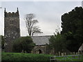
The church of St Stephen at West Putford
Image: © Peter Wood
Taken: 11 Oct 2013
0.12 miles
2
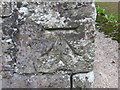
Ordnance Survey Cut Mark
This can be found on the wall of St Stephens Church.
For more detail see : http://www.bench-marks.org.uk/bm52281
Image: © Peter Wood
Taken: 11 Oct 2013
0.12 miles
3
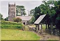
West Putford Church
Another Devon location where my BLIGHT ancestors came from.
Image: © Stephen Bashford
Taken: Unknown
0.13 miles