IMAGES TAKEN NEAR TO
Sutcombe, HOLSWORTHY, EX22 7PQ
Introduction
This page details the photographs taken nearby to EX22 7PQ by members of the Geograph project.
The Geograph project started in 2005 with the aim of publishing, organising and preserving representative images for every square kilometre of Great Britain, Ireland and the Isle of Man.

There are currently over 7.5m images from over14,400 individuals and you can help contribute to the project by visiting https://www.geograph.org.uk
Image Map
Images are licensed for reuse under creativecommons.org/licenses/by-sa/2.0
Notes
- Clicking on the map will re-center to the selected point.
- The higher the marker number, the further away the image location is from the centre of the postcode.
Image Listing (5 Images Found)
Images are licensed for reuse under creativecommons.org/licenses/by-sa/2.0
Image
Details
Distance
3
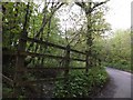
Minor road in woodland at Virworthy
The road has descended and crossed the stream; the hamlet is built close to the bridge, slightly out of the flood plain.
Image: © David Smith
Taken: 11 May 2012
0.06 miles