IMAGES TAKEN NEAR TO
Soldon Cross, HOLSWORTHY, EX22 7PH
Introduction
This page details the photographs taken nearby to Soldon Cross, EX22 7PH by members of the Geograph project.
The Geograph project started in 2005 with the aim of publishing, organising and preserving representative images for every square kilometre of Great Britain, Ireland and the Isle of Man.

There are currently over 7.5m images from over14,400 individuals and you can help contribute to the project by visiting https://www.geograph.org.uk
Image Map
Images are licensed for reuse under creativecommons.org/licenses/by-sa/2.0
Notes
- Clicking on the map will re-center to the selected point.
- The higher the marker number, the further away the image location is from the centre of the postcode.
Image Listing (6 Images Found)
Images are licensed for reuse under creativecommons.org/licenses/by-sa/2.0
Image
Details
Distance
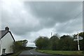
1

Road to Holsworthy
The road just south of Soldon Cross, dropping slightly to cross a tributary of the Tamar at its source.
Image: © Derek Harper
Taken: 24 Jul 2007
0.01 miles
2
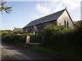
Converted chapel at Soldon Cross
This Victorian chapel a few yards from the crossroads now appears to be a private residence.
Image: © Derek Harper
Taken: 24 Jul 2007
0.05 miles
3

Lane from Soldon Cross
Looking from the crossroads up the lane to Soldon and Sutcombe.
Image: © Derek Harper
Taken: 24 Jul 2007
0.07 miles
4

Soldon Cross
A minor lane from Thurdon to Sutcombe crosses the unclassified road from Holsworthy to Bradworthy.
Image: © Derek Harper
Taken: 24 Jul 2007
0.09 miles