IMAGES TAKEN NEAR TO
Soldon, HOLSWORTHY, EX22 7PF
Introduction
This page details the photographs taken nearby to Soldon, EX22 7PF by members of the Geograph project.
The Geograph project started in 2005 with the aim of publishing, organising and preserving representative images for every square kilometre of Great Britain, Ireland and the Isle of Man.

There are currently over 7.5m images from over14,400 individuals and you can help contribute to the project by visiting https://www.geograph.org.uk
Image Map
Images are licensed for reuse under creativecommons.org/licenses/by-sa/2.0
Notes
- Clicking on the map will re-center to the selected point.
- The higher the marker number, the further away the image location is from the centre of the postcode.
Image Listing (3 Images Found)
Images are licensed for reuse under creativecommons.org/licenses/by-sa/2.0
Image
Details
Distance
1
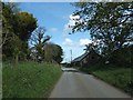
Barns at Soldon
The minor road runs between Soldon Manor and the farm buildings
Image: © David Smith
Taken: 11 May 2012
0.02 miles
2
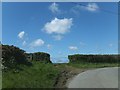
Gates at a bend in the road east of Soldon
Image: © David Smith
Taken: 11 May 2012
0.13 miles
3
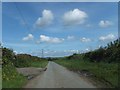
Minor road with wide verges east of Soldon
There is a field entrance on the left of this section of the minor road, which cuts through a corner of the grid square
Image: © David Smith
Taken: 11 May 2012
0.17 miles