IMAGES TAKEN NEAR TO
Milton Damerel, HOLSWORTHY, EX22 7PA
Introduction
This page details the photographs taken nearby to EX22 7PA by members of the Geograph project.
The Geograph project started in 2005 with the aim of publishing, organising and preserving representative images for every square kilometre of Great Britain, Ireland and the Isle of Man.

There are currently over 7.5m images from over14,400 individuals and you can help contribute to the project by visiting https://www.geograph.org.uk
Image Map
Images are licensed for reuse under creativecommons.org/licenses/by-sa/2.0
Notes
- Clicking on the map will re-center to the selected point.
- The higher the marker number, the further away the image location is from the centre of the postcode.
Image Listing (7 Images Found)
Images are licensed for reuse under creativecommons.org/licenses/by-sa/2.0
Image
Details
Distance
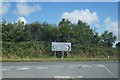
2
A388 approaching Woodford Bridge
Image: © Derek Harper
Taken: 21 Jun 2019
0.13 miles
3
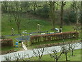
Children's play area
Woodford Bridge Country Club.
Image: © Andy Potter
Taken: 7 Apr 2003
0.18 miles
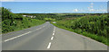
4

The new and old roads at Woodford Bridge, Milton Damerel
Rather than widen the old road, a new one has been constructed alongside it.
Image: © Humphrey Bolton
Taken: 8 Apr 2010
0.18 miles
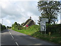
5
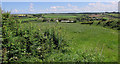
West Bridge Farm
Or is it Woodland View? Maps differ. This view of it is from a gateway by a lay-by on the A388. Beyond is the Torridge valley.
Image: © Derek Harper
Taken: 21 Jun 2019
0.21 miles
6

Holiday homes at Woodford Bridge Country Club, Milton Damerel
These are some of the newer units, typically very spacious one-bedroom houses.
Image: © Humphrey Bolton
Taken: 8 Apr 2010
0.22 miles