IMAGES TAKEN NEAR TO
Milton Damerel, HOLSWORTHY, EX22 7NU
Introduction
This page details the photographs taken nearby to EX22 7NU by members of the Geograph project.
The Geograph project started in 2005 with the aim of publishing, organising and preserving representative images for every square kilometre of Great Britain, Ireland and the Isle of Man.

There are currently over 7.5m images from over14,400 individuals and you can help contribute to the project by visiting https://www.geograph.org.uk
Image Map (Loading...)


Getting Data...Please wait
Leaflet Map data © OpenStreetMap
Images are licensed for reuse under creativecommons.org/licenses/by-sa/2.0
Notes
- Clicking on the map will re-center to the selected point.
- The higher the marker number, the further away the image location is from the centre of the postcode.
Image Listing (5 Images Found)
Images are licensed for reuse under creativecommons.org/licenses/by-sa/2.0
Image
Details
Distance
1
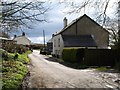
Shop Cross
The lane from Five Lanes Cross reaches the A388 here.
Image: © Derek Harper
Taken: 27 Mar 2008
0.09 miles
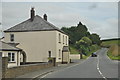
2

Torridge : The A388
A road heading through the Torridge District on the A388.
Image: © Lewis Clarke
Taken: 17 Jul 2014
0.10 miles
3

Gulf filling station at Horrellsford, Milton Damerel
Image: © David Smith
Taken: 19 Aug 2013
0.14 miles
4
Torridge : The A388
Looking along the A388 as it heads through the Torridge District.
Image: © Lewis Clarke
Taken: 17 Jul 2014
0.14 miles
5

W Sanders & Sons Gulf Garage on the A388
Image: © Roy Hughes
Taken: 31 Aug 2022
0.16 miles