IMAGES TAKEN NEAR TO
Pancrasweek, HOLSWORTHY, EX22 7JR
Introduction
This page details the photographs taken nearby to EX22 7JR by members of the Geograph project.
The Geograph project started in 2005 with the aim of publishing, organising and preserving representative images for every square kilometre of Great Britain, Ireland and the Isle of Man.

There are currently over 7.5m images from over14,400 individuals and you can help contribute to the project by visiting https://www.geograph.org.uk
Image Map (Loading...)


Getting Data...Please wait
Leaflet Map data © OpenStreetMap
Images are licensed for reuse under creativecommons.org/licenses/by-sa/2.0
Notes
- Clicking on the map will re-center to the selected point.
- The higher the marker number, the further away the image location is from the centre of the postcode.
Image Listing (13 Images Found)
Images are licensed for reuse under creativecommons.org/licenses/by-sa/2.0
Image
Details
Distance
1
Lane at Lishaperhill Cross
The lane southwards to Pancrasweek from Image
Image: © Derek Harper
Taken: 31 May 2016
0.02 miles
2
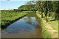
Canal at Lishaperhill
A short stretch of the Holsworthy arm of the Bude Canal has been refilled with water. As Image explains, six miles of the main canal (which runs in front of the wood in the background) can be walked, but this stretch of 160 metres or so is private. Viewed from the lane between Higher Moor Cross and Lishaperhill Cross.
Image: © Derek Harper
Taken: 31 May 2016
0.03 miles
3
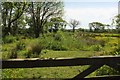
Field, Lishaperhill
On the other side of the lane from Image, and being overtaken by trees as well as buttercups. The former Holsworthy arm of the Bude Canal curves around the left side of the field past trees.
Image: © Derek Harper
Taken: 31 May 2016
0.07 miles
4
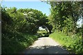
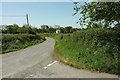
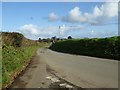
Lane at Lishaperhill Cross
Looking west from the T junction near Lana. The lane leads to Puckland.
Image: © Derek Harper
Taken: 31 May 2016
0.08 miles
5
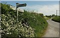
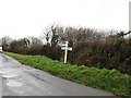
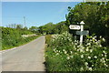
Lishaperhill Cross
The T junction from which Image] and Image] were taken. The signpost, overtaken by cow parsley to a greater extent that the one at the nearby Highermoor Cross Image], is another of those rather dull signposts common in Devon; alas, old signposts seem much rarer in Devon than the attractive traditional ones to be found everywhere in Somerset and Dorset.
Image: © Derek Harper
Taken: 31 May 2016
0.10 miles
7

Footpath beside Bude Aqueduct
Footpath beside Bude Aqueduct, the aqueduct supplies water for the Bude Canal.
Image: © Philip Halling
Taken: 5 Nov 2017
0.11 miles
8
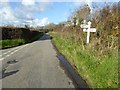
Highermoor Cross
The signpost at the T junction also shown in Image, surrounded by cow parsley.
Image: © Derek Harper
Taken: 31 May 2016
0.11 miles