IMAGES TAKEN NEAR TO
Chilsworthy, HOLSWORTHY, EX22 7JH
Introduction
This page details the photographs taken nearby to EX22 7JH by members of the Geograph project.
The Geograph project started in 2005 with the aim of publishing, organising and preserving representative images for every square kilometre of Great Britain, Ireland and the Isle of Man.

There are currently over 7.5m images from over14,400 individuals and you can help contribute to the project by visiting https://www.geograph.org.uk
Image Map
Images are licensed for reuse under creativecommons.org/licenses/by-sa/2.0
Notes
- Clicking on the map will re-center to the selected point.
- The higher the marker number, the further away the image location is from the centre of the postcode.
Image Listing (6 Images Found)
Images are licensed for reuse under creativecommons.org/licenses/by-sa/2.0
Image
Details
Distance
1
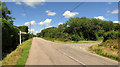
West Ugworthy Cross
Seen from a different direction in Image, giving a clearer picture of the names on the arms.
Image: © Derek Harper
Taken: 21 Jun 2019
0.06 miles
2
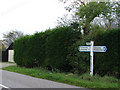
Signpost at West Ugworthy
Looking west.
Image: © Robert Walden
Taken: 26 Oct 2007
0.06 miles
3
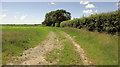
Field boundary near Mountjoys Farm
Just north of West Ugworthy.
Image: © Derek Harper
Taken: 21 Jun 2019
0.13 miles
4
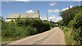
Road past Mountjoys Farm
With Mountjoy's Youldon further along the road to Youldon.
Image: © Derek Harper
Taken: 21 Jun 2019
0.16 miles
5
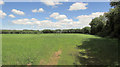
Field near Mountjoys Farm
On the other side of the road from Image
Image: © Derek Harper
Taken: 21 Jun 2019
0.17 miles
6
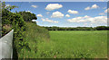
Field near Mountjoys Farm
Looking left from Image], with the roadside hedge on the left.
Image: © Derek Harper
Taken: 21 Jun 2019
0.20 miles