IMAGES TAKEN NEAR TO
Woodacott, HOLSWORTHY, EX22 7BU
Introduction
This page details the photographs taken nearby to EX22 7BU by members of the Geograph project.
The Geograph project started in 2005 with the aim of publishing, organising and preserving representative images for every square kilometre of Great Britain, Ireland and the Isle of Man.

There are currently over 7.5m images from over14,400 individuals and you can help contribute to the project by visiting https://www.geograph.org.uk
Image Map (Loading...)


Getting Data...Please wait
Leaflet Map data © OpenStreetMap
Images are licensed for reuse under creativecommons.org/licenses/by-sa/2.0
Notes
- Clicking on the map will re-center to the selected point.
- The higher the marker number, the further away the image location is from the centre of the postcode.
Image Listing (8 Images Found)
Images are licensed for reuse under creativecommons.org/licenses/by-sa/2.0
Image
Details
Distance
1

War memorial at Woodacott Cross
View north northeast.
Image: © Robert Walden
Taken: 28 Oct 2007
0.07 miles
2
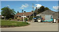
Tractor, Woodacott Cross
A suitably bucolic vehicle parked at the centre of this little village, by the green where five roads meet.
Image: © Derek Harper
Taken: 23 Apr 2016
0.10 miles
3

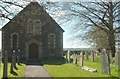
Chapel at Woodacott Cross
View east northeast.
Image: © Robert Walden
Taken: 28 Oct 2007
0.11 miles
4
Methodist chapel, Woodacott Cross
Image: © Derek Harper
Taken: 23 Apr 2016
0.13 miles
5
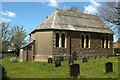
Methodist chapel, Woodacott Cross
Another view of Image The Wesleyan Methodist chapel was built in 1891.
Image: © Derek Harper
Taken: 23 Apr 2016
0.13 miles
6

Approaching Woodacott Cross
Along the lane from Windy Cross.
Image: © Derek Harper
Taken: 23 Apr 2016
0.17 miles
7
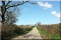
Lane to Cranapool
The lane from Woodacott Cross on a briefly straight stretch.
Image: © Derek Harper
Taken: 23 Apr 2016
0.23 miles
8

Kingsford Farm
Farm buildings seen across a field from the same place as Image], looking left.
Image: © Derek Harper
Taken: 23 Apr 2016
0.23 miles