IMAGES TAKEN NEAR TO
HOLSWORTHY, EX22 7BP
Introduction
This page details the photographs taken nearby to EX22 7BP by members of the Geograph project.
The Geograph project started in 2005 with the aim of publishing, organising and preserving representative images for every square kilometre of Great Britain, Ireland and the Isle of Man.

There are currently over 7.5m images from over14,400 individuals and you can help contribute to the project by visiting https://www.geograph.org.uk
Image Map
Images are licensed for reuse under creativecommons.org/licenses/by-sa/2.0
Notes
- Clicking on the map will re-center to the selected point.
- The higher the marker number, the further away the image location is from the centre of the postcode.
Image Listing (6 Images Found)
Images are licensed for reuse under creativecommons.org/licenses/by-sa/2.0
Image
Details
Distance
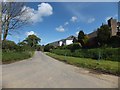

4
Road at Brendon south of Holsworthy Beacon
Image: © David Smith
Taken: 11 May 2012
0.23 miles
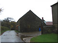
5
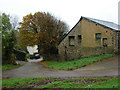
Old farm buildings at Brendon (2)
View south southeast.
Image: © Robert Walden
Taken: 28 Oct 2007
0.24 miles
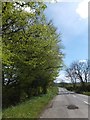
6
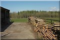
Logs near Holsworthy Beacon
From the lane east of Holsworthy Beacon towards Cranapool, with an unnamed plantation in the background.
Image: © Derek Harper
Taken: 23 Apr 2016
0.25 miles