IMAGES TAKEN NEAR TO
Gloyn Park, HOLSWORTHY, EX22 7BD
Introduction
This page details the photographs taken nearby to Gloyn Park, EX22 7BD by members of the Geograph project.
The Geograph project started in 2005 with the aim of publishing, organising and preserving representative images for every square kilometre of Great Britain, Ireland and the Isle of Man.

There are currently over 7.5m images from over14,400 individuals and you can help contribute to the project by visiting https://www.geograph.org.uk
Image Map
Images are licensed for reuse under creativecommons.org/licenses/by-sa/2.0
Notes
- Clicking on the map will re-center to the selected point.
- The higher the marker number, the further away the image location is from the centre of the postcode.
Image Listing (3 Images Found)
Images are licensed for reuse under creativecommons.org/licenses/by-sa/2.0
Image
Details
Distance
1
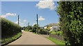
Road at Chilsworthy
With houses on the right, this is the road heading out of the village towards Coldharbour Cross.
Image: © Derek Harper
Taken: 21 Jun 2019
0.22 miles
2

Chapel Lane, Chilsworthy
The lane passes the chapel shown in Image
Image: © Derek Harper
Taken: 21 Jun 2019
0.23 miles
3
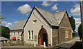
Chilsworthy Methodist Church
Formerly described as Chilsworthy Wesleyan Methodist Chapel. The date 1886 appears above the door. The chapel is also shown at Image and Image
Image: © Derek Harper
Taken: 21 Jun 2019
0.23 miles