IMAGES TAKEN NEAR TO
EX22 7AX
Introduction
This page details the photographs taken nearby to EX22 7AX by members of the Geograph project.
The Geograph project started in 2005 with the aim of publishing, organising and preserving representative images for every square kilometre of Great Britain, Ireland and the Isle of Man.

There are currently over 7.5m images from over14,400 individuals and you can help contribute to the project by visiting https://www.geograph.org.uk
Image Map (Loading...)


Getting Data...Please wait
Leaflet Map data © OpenStreetMap
Images are licensed for reuse under creativecommons.org/licenses/by-sa/2.0
Notes
- Clicking on the map will re-center to the selected point.
- The higher the marker number, the further away the image location is from the centre of the postcode.
Image Listing (4 Images Found)
Images are licensed for reuse under creativecommons.org/licenses/by-sa/2.0
Image
Details
Distance
2
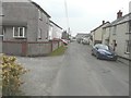
Bradworthy
In the centre of the village of Bradworthy is a large square, this is the northern end of it.
Image: © Philip Halling
Taken: 17 Apr 2007
0.24 miles
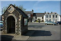
3
War memorial and church, Bradworthy
The war memorial and church taken from Bradworthy Square. The sign claims this is the largest village square in the West Country.
Image: © Thor Beverley
Taken: 21 Feb 2007
0.24 miles
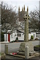
4
St Peter's Well
Overflowing at the time https://www.megalithic.co.uk/article.php?sid=15321
Image: © Sandy Gerrard
Taken: Unknown
0.24 miles