IMAGES TAKEN NEAR TO
North Tamerton, HOLSWORTHY, EX22 6SA
Introduction
This page details the photographs taken nearby to EX22 6SA by members of the Geograph project.
The Geograph project started in 2005 with the aim of publishing, organising and preserving representative images for every square kilometre of Great Britain, Ireland and the Isle of Man.

There are currently over 7.5m images from over14,400 individuals and you can help contribute to the project by visiting https://www.geograph.org.uk
Image Map
Images are licensed for reuse under creativecommons.org/licenses/by-sa/2.0
Notes
- Clicking on the map will re-center to the selected point.
- The higher the marker number, the further away the image location is from the centre of the postcode.
Image Listing (5 Images Found)
Images are licensed for reuse under creativecommons.org/licenses/by-sa/2.0
Image
Details
Distance
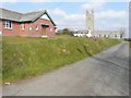
1

Looking west along the road through North Tamerton
Image: © John Baker
Taken: 26 Mar 2013
0.11 miles
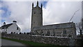
2
Looking north to the church of St Denis
With Victoria Hall on the left.
Image: © John Baker
Taken: 26 Mar 2013
0.16 miles
3
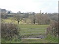
The tower of St Denis' church
Seen across the flood-plain of the River Tamar from a lane to the east.
Image: © John Baker
Taken: 26 Mar 2013
0.16 miles
5

North Tamerton Methodist Church
The church has two dates; a plaque on the porch reads "United Methodist Church 1869", while the one on the façade gives "Methodist Church 1932", so presumably one is the original building and the other a date of rebuilding or restoration. This is on the western outskirts of North Tamerton on the road to Wilsworthy Cross.
Image: © Derek Harper
Taken: 9 Nov 2007
0.23 miles