IMAGES TAKEN NEAR TO
Lana, HOLSWORTHY, EX22 6QR
Introduction
This page details the photographs taken nearby to Lana, EX22 6QR by members of the Geograph project.
The Geograph project started in 2005 with the aim of publishing, organising and preserving representative images for every square kilometre of Great Britain, Ireland and the Isle of Man.

There are currently over 7.5m images from over14,400 individuals and you can help contribute to the project by visiting https://www.geograph.org.uk
Image Map
Images are licensed for reuse under creativecommons.org/licenses/by-sa/2.0
Notes
- Clicking on the map will re-center to the selected point.
- The higher the marker number, the further away the image location is from the centre of the postcode.
Image Listing (2 Images Found)
Images are licensed for reuse under creativecommons.org/licenses/by-sa/2.0
Image
Details
Distance

2
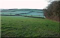
Fields near Tetcott
From the edge of the wood; and (right) surrounding Hut Cottages, a view across the head of a minor side valley of the Tamar.
Image: © Derek Harper
Taken: 19 Jan 2017
0.16 miles