IMAGES TAKEN NEAR TO
HOLSWORTHY, EX22 6JW
Introduction
This page details the photographs taken nearby to EX22 6JW by members of the Geograph project.
The Geograph project started in 2005 with the aim of publishing, organising and preserving representative images for every square kilometre of Great Britain, Ireland and the Isle of Man.

There are currently over 7.5m images from over14,400 individuals and you can help contribute to the project by visiting https://www.geograph.org.uk
Image Map
Images are licensed for reuse under creativecommons.org/licenses/by-sa/2.0
Notes
- Clicking on the map will re-center to the selected point.
- The higher the marker number, the further away the image location is from the centre of the postcode.
Image Listing (6 Images Found)
Images are licensed for reuse under creativecommons.org/licenses/by-sa/2.0
Image
Details
Distance
1
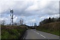
Communications mast and industrial buildings at Crossparks
Image: © David Smith
Taken: 14 Apr 2016
0.02 miles
2
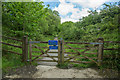
Ruby Way
At this point the path narrows and horse riding is prohibited.
Image: © Guy Wareham
Taken: 22 May 2016
0.11 miles
3

A3072 eastbound
Towards Crossparks Farm.
Image: © Julian P Guffogg
Taken: 12 Aug 2013
0.19 miles
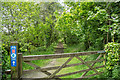
4
Ruby Way
Heading towards Holsworthy on National Cycle Route 3.
Image: © Guy Wareham
Taken: 22 May 2016
0.20 miles
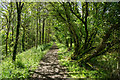
5
Ruby Way
Part of National Cycle Route 3 following the trackbed of the dismantled Halwill Junction to Holsworthy Branch line.
Image: © Guy Wareham
Taken: 22 May 2016
0.23 miles
6

A3072 near entrance to Simpson Barton
Image: © Julian P Guffogg
Taken: 12 Aug 2013
0.24 miles