IMAGES TAKEN NEAR TO
West Chilla, BEAWORTHY, EX21 5XQ
Introduction
This page details the photographs taken nearby to EX21 5XQ by members of the Geograph project.
The Geograph project started in 2005 with the aim of publishing, organising and preserving representative images for every square kilometre of Great Britain, Ireland and the Isle of Man.

There are currently over 7.5m images from over14,400 individuals and you can help contribute to the project by visiting https://www.geograph.org.uk
Image Map (Loading...)


Getting Data...Please wait
Leaflet Map data © OpenStreetMap
Images are licensed for reuse under creativecommons.org/licenses/by-sa/2.0
Notes
- Clicking on the map will re-center to the selected point.
- The higher the marker number, the further away the image location is from the centre of the postcode.
Image Listing (4 Images Found)
Images are licensed for reuse under creativecommons.org/licenses/by-sa/2.0
Image
Details
Distance
1

Home Farm, West Chilla
Looking up the track to the farmhouse and its outbuildings from the lane through the hamlet.
Image: © Derek Harper
Taken: 7 Jul 2007
0.08 miles
2

West Chilla
A pretty hamlet on an intriguing lane north of Halwill Junction. The thatched West Chilla Farm is an organic farm.
Image: © Derek Harper
Taken: 7 Jul 2007
0.11 miles
3
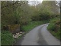
Bridge near West Chilla
A stream bridge on a minor road north of Chilla Chapel
Image: © David Smith
Taken: 11 May 2012
0.15 miles
4
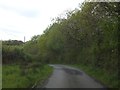
Minor road near Little Park Farm
Although the verge on the left is wide, the rushes show that it would be risky to try to use it with a vehicle.
Image: © David Smith
Taken: 11 May 2012
0.20 miles