IMAGES TAKEN NEAR TO
Shebbear, BEAWORTHY, EX21 5RF
Introduction
This page details the photographs taken nearby to EX21 5RF by members of the Geograph project.
The Geograph project started in 2005 with the aim of publishing, organising and preserving representative images for every square kilometre of Great Britain, Ireland and the Isle of Man.

There are currently over 7.5m images from over14,400 individuals and you can help contribute to the project by visiting https://www.geograph.org.uk
Image Map
Images are licensed for reuse under creativecommons.org/licenses/by-sa/2.0
Notes
- Clicking on the map will re-center to the selected point.
- The higher the marker number, the further away the image location is from the centre of the postcode.
Image Listing (5 Images Found)
Images are licensed for reuse under creativecommons.org/licenses/by-sa/2.0
Image
Details
Distance
1
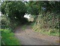
Track to Moortown
Track runs from Battledown Cross - Stibb Cross road.
Image: © Geoff Gartside
Taken: 30 Sep 2007
0.08 miles
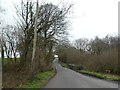
2
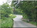
Road approaching Moortown
A rather busy country road that links Brandis Corner to Stibb Cross, here descending to cross a headwater of Combe Lake.
Image: © Derek Harper
Taken: 21 Jun 2019
0.15 miles
3
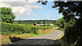
Road at Fulford Bridge
The road to Stibb Cross near Badworthy.
Image: © Derek Harper
Taken: 21 Jun 2019
0.19 miles
4
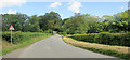
Fulford Bridge
Crossing the Combe Lake stream
Image: © David Smith
Taken: 21 Mar 2019
0.20 miles