IMAGES TAKEN NEAR TO
Highampton, BEAWORTHY, EX21 5LH
Introduction
This page details the photographs taken nearby to EX21 5LH by members of the Geograph project.
The Geograph project started in 2005 with the aim of publishing, organising and preserving representative images for every square kilometre of Great Britain, Ireland and the Isle of Man.

There are currently over 7.5m images from over14,400 individuals and you can help contribute to the project by visiting https://www.geograph.org.uk
Image Map
Images are licensed for reuse under creativecommons.org/licenses/by-sa/2.0
Notes
- Clicking on the map will re-center to the selected point.
- The higher the marker number, the further away the image location is from the centre of the postcode.
Image Listing (4 Images Found)
Images are licensed for reuse under creativecommons.org/licenses/by-sa/2.0
Image
Details
Distance
1

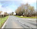
A3072 passing woodland at Pulworthy
The modern house is on the right, just before the woodland and the line of trees which shield the building from the west
Image: © David Smith
Taken: 14 Apr 2016
0.13 miles

4
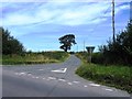
Road junction on Pulworthy Moor
The road to the right crosses the Pulworthy Brook; the A3072 follows the edge of the moorland associated with the stream
Image: © David Smith
Taken: 14 Apr 2016
0.22 miles