IMAGES TAKEN NEAR TO
Ashwater, BEAWORTHY, EX21 5DD
Introduction
This page details the photographs taken nearby to EX21 5DD by members of the Geograph project.
The Geograph project started in 2005 with the aim of publishing, organising and preserving representative images for every square kilometre of Great Britain, Ireland and the Isle of Man.

There are currently over 7.5m images from over14,400 individuals and you can help contribute to the project by visiting https://www.geograph.org.uk
Image Map
Images are licensed for reuse under creativecommons.org/licenses/by-sa/2.0
Notes
- Clicking on the map will re-center to the selected point.
- The higher the marker number, the further away the image location is from the centre of the postcode.
Image Listing (2 Images Found)
Images are licensed for reuse under creativecommons.org/licenses/by-sa/2.0
Image
Details
Distance
1
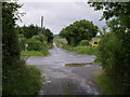
Mount Lane
A crossroads on the A388, albeit that of a modest footpath and Mount Lane (opposite, leading to Henford) with the A388 Launceston-Holsworthy main road.
Image: © Derek Harper
Taken: 15 Jun 2007
0.01 miles
2
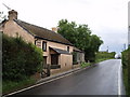
Cottage on A388
This looks a precarious place for a pedestrian, and there's no speed restriction. The cottage is about 130 metres from the junction at Mount Lane on the Launceston-Holsworthy Road.
Image: © Derek Harper
Taken: 15 Jun 2007
0.08 miles