IMAGES TAKEN NEAR TO
BEAWORTHY, EX21 5AW
Introduction
This page details the photographs taken nearby to EX21 5AW by members of the Geograph project.
The Geograph project started in 2005 with the aim of publishing, organising and preserving representative images for every square kilometre of Great Britain, Ireland and the Isle of Man.

There are currently over 7.5m images from over14,400 individuals and you can help contribute to the project by visiting https://www.geograph.org.uk
Image Map
Images are licensed for reuse under creativecommons.org/licenses/by-sa/2.0
Notes
- Clicking on the map will re-center to the selected point.
- The higher the marker number, the further away the image location is from the centre of the postcode.
Image Listing (6 Images Found)
Images are licensed for reuse under creativecommons.org/licenses/by-sa/2.0
Image
Details
Distance
1
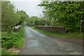
Bridge over dismantled railway
The bridge carries the road to Patchacott over the trackbed of the dismantled railway from Medlon Junction to Holsworthy.
Image: © Guy Wareham
Taken: 12 May 2016
0.07 miles
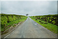
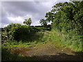
2
Public Byway to the lane to Beamsworthy
Image: © Guy Wareham
Taken: 12 May 2016
0.08 miles
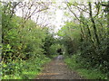
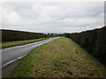
4
Beaworthy Byway 9
This byway links the lanes to Patchacott and Beamsworthy, and the map suggests it formed part of a longer route that may have disrupted by the construction of the nearby railway. Here it emerges from an enclosed stretch at the Patchacott end to run beside fields across one of the highest parts of Broadbury.
Image: © Derek Harper
Taken: 6 Jul 2007
0.16 miles