IMAGES TAKEN NEAR TO
Patchacott, BEAWORTHY, EX21 5AR
Introduction
This page details the photographs taken nearby to EX21 5AR by members of the Geograph project.
The Geograph project started in 2005 with the aim of publishing, organising and preserving representative images for every square kilometre of Great Britain, Ireland and the Isle of Man.

There are currently over 7.5m images from over14,400 individuals and you can help contribute to the project by visiting https://www.geograph.org.uk
Image Map
Images are licensed for reuse under creativecommons.org/licenses/by-sa/2.0
Notes
- Clicking on the map will re-center to the selected point.
- The higher the marker number, the further away the image location is from the centre of the postcode.
Image Listing (3 Images Found)
Images are licensed for reuse under creativecommons.org/licenses/by-sa/2.0
Image
Details
Distance
1
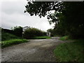
Patchacott
The only visible inhabitants of this little hamlet on Broadbury were numerous elderly dogs wandering around - or sitting in the road. The rear end of one is on the left. The right-hand of these buildings is Beaworthy Parish Hall; the parish church is 2 kilometres away.
Image: © Derek Harper
Taken: 6 Jul 2007
0.06 miles
2
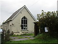
The Village Hall, Patchacott
About to go undergo restoration and extension.
Image: © Jonathan Thacker
Taken: 18 Sep 2017
0.06 miles